
Slightly cooler temps are expected for this weekend as a cool pool of air aloft gradually sinks to the ground. This pool is also responsible for added instability shower chances for this afternoon and tomorrow afternoon.
Showers are already ongoing thanks to a low pressure system moving through. Numerous showers will be found outside of I-495, and there could even be a few thunderstorms. Any storm has the chance to produce lightning, thunder, and small or soft hail called graupel. Winds may be gusty in eastern and southeastern New England, adding to the cool feel as highs only reach the upper 50s with more clouds around.
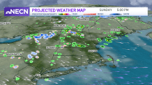
We stay mainly dry for Saturday night as the showers head northeast. Lows drop to the 40s and 30s with 20s found in the north country. Sunday will be drier than Saturday with more sun, but in the afternoon daytime heating will bring all some cumulus clouds to puff up. Also, a weak shortwave swings in the potential for some daytime pop up showers again through sunset. Otherwise, most stay dry with highs in the 40s to mid 50s south.
Get Boston local news, weather forecasts, lifestyle and entertainment stories to your inbox. Sign up for NBC Boston’s newsletters.
Next week we slowly heat things up as the jet stream positions itself far to the north of New England. Highs will be in the 60s for Monday, then in the low 70s inland for Tuesday into Wednesday. At the coast, temps will stay in the 50s to 60s thanks to lack of a dominant wind and local afternoon seabreezes. Thursday we may deal with a sharp backdoor cold front…if that happens, highs will stay in the 50s at the coast, far west nearing 70.
