The mighty weather pendulum is about to swing back the other way. There’s only one way to go from here - that is up.
We set record low high temperatures yesterday at 55 to 60°, rivaling the afternoon of July 3, 1914 for coldest on record.
We also saw rainfall measured in inches once again. Parts of New England have had more than a month's worth of rain since the heat wave ended on Wednesday, Both Wilbraham and Leominster, Massachusetts check in with more than 5.5 inches since Wednesday.
The temperature in Boston on Wednesday was 100°. The temperature yesterday was 60°. If you add those up and divide them by two, you get 80°, that’s the average high temperature for this time of year.
Get Boston local news, weather forecasts, lifestyle and entertainment stories to your inbox. Sign up for NBC Boston’s newsletters.
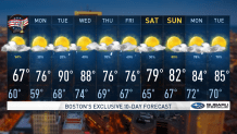
New England weather is a balance of the extremes, often swinging from one to the other like a pendulum. Today we are heading back toward warmer weather, but we have a way to go to get to 80°. That may happen tomorrow.
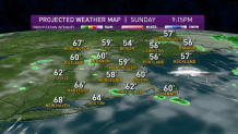
The old front, and the upper level low, are finally lifting off to the north and east today. The airmass is gradually drying out, clouds and damp weather this morning give away to a mixture of sun and clouds with just a few scattered showers this afternoon. The atmosphere is quite unstable and even though the showers are scattered around, they could be briefly moderate. High temperature today in the 60s.
Independence Day fireworks look much better for tonight than the last couple nights. The low clouds and fog should be gone and any evening showers should dry up, for a pleasant viewing experience.
The temperature will be a little chilly, it’s sweatshirt weather, in the 50s and 60s. Also, mosquitoes are flourishing after all this wet weather, so the insect repellent would be very helpful.
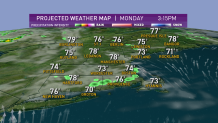
Tomorrow we have a warm front coming through with sunshine mixed in with clouds, a spot shower or late day thunderstorm is possible, high temperature in the 70s to 80°.
We are warm to hot and humid Tuesday with sunshine and a spot afternoon thunderstorm, highs near 90°.
We start gradually cooling on Wednesday, though still well into the 80s with a few thunderstorms.
Then we are going to have another front come to New England and slow down with off and on rain to finish out the week. It may end up being heavy rain if the remnant of tropical cyclone Elsa holds together and makes it up here. Stay tuned to the latest developments and our First Alert 10-day forecast.