We’re rounding the corner on a big warmup. Today will be spent with scattered showers between 9 a.m. and 1 p.m. and somewhat mild temperatures as a gusty south wind combines with plentiful clouds to keep us in the mid-70s. You may notice a slight increase in the humidity as the day wears on, but it won’t be anywhere near stifling.
Tomorrow is the hottest of this stretch…and the 10-day forecast, for that matter. Southwest winds, plenty of sun, and high humidity will make it feel more like the 90s as we soar into the mid and upper 80s. Any departing showers (or brief downpours) will scoot off Cape very early in the morning. This leaves us with tons of sun before the cold front slices into the heat mid/late day.
Right now, there are some signs that we’re in the crosshairs for storms just after noon in Greater Worcester and then mid-afternoon in Greater Boston. All the ingredients are there for thunderstorms, but like every “potentially strong storm event,” it comes down to timing and synchronicity.

Get Boston local news, weather forecasts, lifestyle and entertainment stories to your inbox. Sign up for NBC Boston’s newsletters.
If we can sustain a batch of unfettered lift along the front (with good upper level dynamics), we’ll get the goods. If not, then very few storms will pop, and many of us will come away with just a shift in the wind and some ominous clouds in the distance.
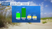
The bottom line is that the cooler, less humid air is inevitably coming in. We’ll see the humidity drop on Friday night, then continue with a refreshing airmass for the entire weekend. Saturday starts bright, with clouds building (AND a brief sprinkle) in the afternoon. Sunday is more of the same as a cool pool of air settles in high above all of New England. Temps recover a bit early next week.