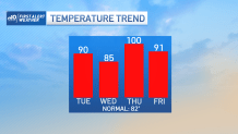
Pockets of clouds Tuesday morning will break up for plenty of sunshine regionwide. That will mean rebounding temperatures to around and over 90 degrees through the afternoon, ahead of an approaching cold front set to cross the region Tuesday evening.
This cold front touched off scattered showers and thunder Monday afternoon and evening in Ontario and should do the same thing in New England Tuesday late day and evening. While isolated storms, fueled by heat and moderate humidity of dew point temperatures in the middle 60s, may produce a very localized damaging downburst wind, most storms aren’t expected to be damaging.
A severe thunderstorm warning was issued at 4:54 p.m. through 5:30 p.m. for parts of Maine. Click here for the latest severe weather alerts.
Get Boston local news, weather forecasts, lifestyle and entertainment stories to your inbox. Sign up for NBC Boston’s newsletters.
That said, lightning is a danger in and of itself so "when thunder roars, go indoors." If you can hear thunder, the storm is close enough to be a threat. Rain amounts on our parched landscape will be minimal, with even the communities that receive a direct hit from storms unlikely to pick up more than a quarter to a half inch of rain, with most of us seeing far less than that.
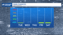
The chance of rain in any given spot of northern and western New England Tuesday afternoon to evening is about 70-90%. That chance drops to a 50/50 proposition around Boston and Providence and even less in southeast New England, where a stray, leftover shower may arrive in the first part of the overnight.
Less humid air arrives by Wednesday morning for most of New England and stays the day, though the change of air on Cape Cod will be less noticeable as humidity sits in waiting over our south coastal waters, ready to make a comeback along with deep heat Thursday.
As it stands now, our First Alert Team believes Boston will hit 98 or 99 degrees Thursday, breaking the old record of 96 degrees set back in 1928. Hartford’s record of 95 degrees from 1944 also looks vulnerable.
With moderate humidity for areas near and south of the Mass. Turnpike, heat index values in these parts of southern New England will exceed 100 degrees, warranting the continuation of our First Alert for impact to the body. A sluggish cold front arrives Friday, but it will be so slow to cross New England that high temperatures should exceed 90 degrees in much of southern New England (80s north) before thunderstorms erupt during the afternoon and evening.
As the front slows to a crawl nearby, the push of cooler air also slows, meaning Saturday may only be a few degrees cooler, though that may be just enough to preclude a heat wave for some if the temperature Saturday fails to cross 90 degrees. Either way, heat over 90 degrees and increased humidity returns Sunday with a chance of late day thunder, then another slow moving cold front Monday brings scattered storms before a decided cooling trend – into the lower 80s – is expected thereafter next week in our exclusive First Alert 10-day forecast.