Severe thunderstorm warnings were issued in the Boston and Worcester areas, as well as in southern New Hampshire, Monday morning, the beginning of what was expected to be a stormy day.
See severe weather warnings in your area here, and live radar below.
Monday marks the end of an amazing stretch of heat and humidity which was responsible for daily record highs Sunday in Boston (100 degrees), Providence (98 degrees) and Hartford (tied 96 degrees)!
Much of the region has experienced temperatures 90 degrees or higher the past six days and some may have the opportunity to extend the "heat wave" to seven in a row today, that is, if the sun peeks through the clouds long enough ahead of an approaching frontal system.
Get Boston local news, weather forecasts, lifestyle and entertainment stories to your inbox. Sign up for NBC Boston’s newsletters.
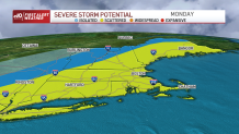
The big story Monday won’t be the heat and humidity, but a cold front which will be passing through the region likely producing strong to severe thunderstorms in the morning through the early evening. The main hazard with these storms will be damaging wind, hail and downpours. An isolated tornado can’t be ruled out as well.
A severe thunderstorm warning was issued before 8:30 a.m. Monday for parts of western and southwestern Maine through 9:15 a.m.
Click here to see an updated list of weather alerts.
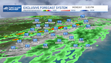
We will continue to be in First Alert Red through early Monday night due to the severe threat. The timing of the storms will be Monday morning into the early afternoon across northern New England, late morning into the afternoon in central areas and mid-afternoon to evening in southern areas.
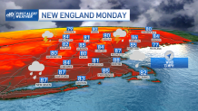
Please take every precaution to take proper shelter if your community is issued a warning. Highs will be mostly in the upper 80s south, low to mid 80s north along with a southwest wind gusting over 25 miles per hour at times.
Showers and storms will linger through early Monday night, some still may be severe across southeast Massachusetts, Connecticut and Rhode Island before exiting off the coast after midnight. Clouds will decrease thereafter along with the oppressive humidity by Tuesday morning. Lows will drop to around 70 south, 60s north.
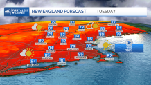
Tuesday through Thursday will feature more seasonable and tolerable temperatures, in the 80s along with noticeably less humidity as high pressure builds into the region!
Our next shot for showers and storms arrives late Thursday into Friday as indicated on our Exclusive 10-Day Forecast. There is still a bit of uncertainty on the timing of those, so stay tuned!
Have a great Monday!