
Severe thunderstorm warnings were issued late Monday night in parts of Essex County and Middlesex County in Massachusetts. They were lifted shortly after midnight.
Click here to see active weather alerts.
An earlier version of this blog follows
Get Boston local news, weather forecasts, lifestyle and entertainment stories to your inbox. Sign up for NBC Boston’s newsletters.
A large, upper atmospheric storm spiraling in the sky over the Great Lakes houses cool air and energy, and is launching bundles of energy into New England Monday and Tuesday.
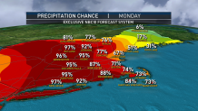
Coupled with an increasing south wind that will produce gusts over 30 mph in Southeast Massachusetts and the South Coast of New England late Monday, increasing moisture in the air, the incoming energetic disturbances will serve to focus recurring showers. After clouds thickened Monday morning, showers continue expanding across New England from southwest to northeast, arriving last (aside from a sprinkle or light shower) to Cape Cod late Monday and much of Maine Monday evening to night, but dropping increasing showers on the rest of New England from particularly late morning onward.
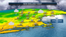
The air may feel just a bit humid by the end of Monday in parts of southern New England and this moisture will result in pockets of fog scattered across New England Monday night. Southern New England may find some embedded downpours and thunder in overnight rain, helping to boost rainfall totals above the average third of an inch to between three quarters of an inch and one inch where thunderstorms crop up.
Weather Stories


Rain is expected to continue Tuesday morning for a somewhat slowed morning commute, then will let up from west to east, mid-morning to late afternoon, respectively, with breaks of sun likely to emerge for many by day’s end, excepting the Cape and much of Maine, since the rain will be exiting east.
Wednesday and Thursday bring cool but dry fall air under a fair sky with overnight frost in central, western and northern New England possible Wednesday and Thursday nights. The remnant energy from the upper level storm over the Great Lakes will swing east Friday, raising the chance for a scattered shower as it passes, then the door opens to milder air for both weekend days with a blend of sun and clouds and high temperatures of 65 to 70 degrees expected!
New England has been on a roll, with weekends looking great when they first pop onto the 10-day forecast and continuing to look great until they come to fruition, and this weekend appears, at least as of right now, to be no exception to the pattern. Even as the chance of showers builds in the first half of next week — toward the end of our exclusive First Alert 10-day forecast — at this early juncture it looks like relatively mild temperatures well into the 60s – warmer than normal for late October when the average high is 59 degrees.
