
More clouds roll into the forecast for today, but our highs will still reach the upper 60s and low 70s. Isolated sprinkles or showers develop today as a weak shortwave moves through the northeast. Most of the rain will be in northern New England, with a spot shower south.
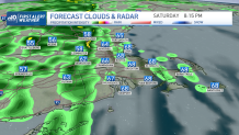
A larger system moves in for Saturday. First a warm front lifts through from southwest to northeast Saturday morning. This will bring in more clouds, a few showers, higher humidity and a gusty south wind along with highs in the mid 70s.
There will be plenty of dry opportunities during the day in southern New England to go apple-picking, or to the pumpkin patch. The sun will even pop out for some time before sunset.
Get Boston local news, weather forecasts, lifestyle and entertainment stories to your inbox. Sign up for NBC Boston’s newsletters.
Then second, the cold front approaches western New England right at sunset and this brings in widespread rain with a couple thunderstorms. Any storm that moves through could produce isolated wind damage. The rain heads into Boston after dinnertime, and overnight. The rain moves offshore by late morning.
After this system, autumn air rushes in. Sunday will be a tad blustery compared to what we have had lately. Highs in the 60s, breezy, and clearing skies in the afternoon.
Chilly temperatures will return for Monday and Tuesday mornings, with perhaps some frost in northern New England and in higher elevations across Massachusetts. A small warm up returns midweek next week with temperatures around 70, before another cooler air mass settles in for next weekend.
