The downpours came and went, but some of that warmth and showers from yesterday lingers. We’re still in the mild airmass, so 60 degrees is within reach of many communities early this afternoon.
Later on, the cooler air arrives with an increasing northwest wind, so if you’re planning on dining out for the first night of outdoor dining in Boston, bring a couple of layers and get the seat next to the patio heater.
Cooler air will be present for tomorrow, but with April sun we’ll still be able to cozy up to the mid-50s. Breezes will be brisk, but the sky will stay mostly clear. Sunday is another matter, as the clouds move in and the showers sweep in from the south in the afternoon.
Sign up for our Breaking newsletter to get the most urgent news stories in your inbox.
Get Boston local news, weather forecasts, lifestyle and entertainment stories to your inbox. Sign up for NBC Boston’s newsletters.
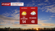
As this slow-moving system crawls through, our temperatures will continue to dip through Sunday night. It’s even possible that some wet snow (gasp) mixes in across the higher terrain of Worcester county. While we’re not expecting any accumulation, it’s very telling of the seesaw pattern we’ve been in since late January.
Monday brightens, Tuesday cools a smidge and more showers will come by midweek. Spring in New England rolls on. Have a great weekend!