Conditions will continue to improve as we head into this evening and into the early portions of tonight. We’ll remain on the windy side with west/southwest winds continuing to gust over 25 mph at times along with a few spot rain showers. The higher elevations of western and northern New England will continue to see snow showers tonight through the early morning hours, where we could see a coating to a couple of inches of snow.
Skies clear, temps drop overnight
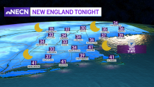
Overnight, high pressure will build into the region from the south allowing our skies to clear, with the exception of the higher elevations of western and northern New England where we’ll see upsloping winds produce some snow showers. Southwest winds will turn more out of the west and continue to gust up to 25 mph. Temperatures will drop into the mid 30s to 40 south, and around freezing to mid 30s north.
Get Boston local news, weather forecasts, lifestyle and entertainment stories to your inbox. Sign up for NBC Boston’s newsletters.
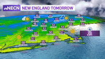
Dry and sunny start to Wednesday
It will be drier Wednesday with sunshine and afternoon clouds. Winds will still be on the active side with gusts over 20 mph at times, diminishing by late in the day. Expect high temperatures to reach seasonable levels, in the 50s south, upper 40s to low 50s north.
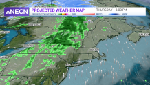
We’re still on track to see a warming trend Thursday and Friday, but that comes with the risk of a few showers across central and northern New England Thursday as a warm front passes by. Highs will reach the 60s Thursday, mid to upper 60s Friday! Right now, the weekend is looking slightly cooler with mostly dry conditions as featured on our Exclusive 10-Day Forecast.