
Our first winter weather event of the week is a pretty easy-going one Monday.
Light snow and rain expanding east across New England is falling into air temperatures mostly above freezing and onto roads that began the day above freezing but may dip cool enough for a slushy film to develop in locales that see snow amounts around an inch.
Specifically, this could happen in central and southern Connecticut away from the coast, central and northern Rhode Island and interior southeast Massachuetts and the suburbs south of Boston.
Farther north, moisture will be limited for only a dusting or coating of snow... Farther south on and near Cape Cod and the immediate South Coast, temperatures will be warm enough for mostly rain with just an ending of wet snow for a possible coating.
The bigger impact may come overnight with black ice as the sky clears and temperatures fall below freezing soon after dark, likely requiring road treatments in the first part of the night.
Tuesday will be bright with sun - but chilly! We'll see high temperatures in the 30s with wind chill factor in the 20s at the warmest time of the day.
Weather Stories

Wednesday brings increasing clouds but no snow until after dark, when a meaningful snowstorm unfolds into Thursday, with the heaviest snow expected late Wednesday night through Thursday morning... tapering Thursday midday and afternoon for a late day clean-up and dry Friday.
Of course, the question is how much snow: Plowable amounts of greater than two or three inches seem likely in most of the southern half of New England with less if any in the North Country, but a zone of six to 10 inches with locally higher amounts will be likely.
Exactly where depends on precise storm track - at this point the most likely axis would be along and either side of the Massachusetts Turnpike, though a more southern track would put this axis over interior southeast Massachusets and northern Connecticut and Rhode Ilsand.
Either way, we’re in the mindset for snow. Just how much wind will depend on the storm track, but a gusty wind with driving snow for whiteout conditions certainly is a possibility, particularly near the coast, and coastal flooding at this point appears mostly minor, though could border on moderate at Nantucket and could increase in scale if the storm strengthens quickly enough.
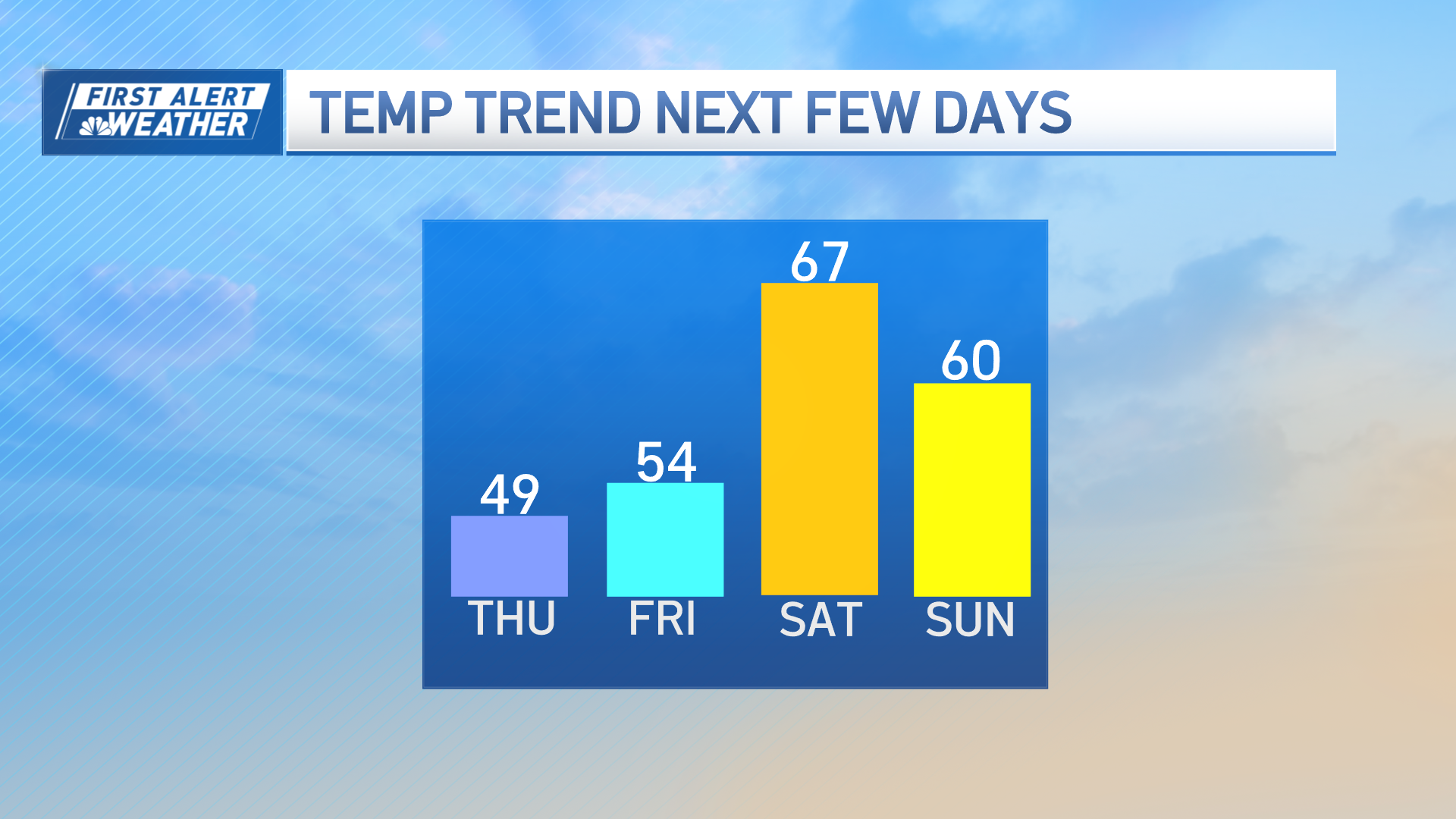
After Thursday, our next chance of some snow and rain is Sunday, which doesn’t look as strong right now but will be watched carefully by our team. Next week doesn’t look to be as cold in our exclusive First Alert 10-day forecast.
