Severe thunderstorm warnings have been issued in parts of four New England states Friday afternoon: Massachusetts, including in the Boston area; Rhode Island; Connecticut; and Maine. See severe thunderstorm warnings in your area here.
We are topping 90° in many spots in southern and eastern New England Friday. The sky is dimmed a bit by smoke from fires burning on the West Coast, so it really qualifies as hazy, hot and humid.
With the dew point reading in the 70s, that puts the heat index at 95° or higher in many spots. The exception is far northern New England, where the next front is already generating showers and thunderstorms, and is slowly settling south.
That means there's the chance for showers and thunderstorms in central and southern New England later in the day and this evening, but they should be few and far between.
Get Boston local news, weather forecasts, lifestyle and entertainment stories to your inbox. Sign up for NBC Boston’s newsletters.
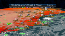
It’s a moisture-rich environment, with a good amount of wind high up in the sky, which means that any storm can generate torrential downpours and potentially locally damaging wind gusts. Wind on the ground is from the southwest gusting past 20 miles an hour near the south coast.
The weather front is going to stall over New England for the next several days.
Overnight we should be mostly cloudy with a chance of showers, fog and drizzle, maybe a thunderstorm, low temperature in the 70s. Timing the weekend precipitation is a huge challenge, as waves of energy are going to be rippling along the stalled front.
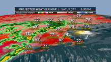
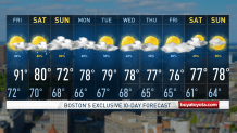
Most of southern New England should be warm and humid again tomorrow with a chance of afternoon and evening thunderstorms highs in the 80s. It looks cooler for northern New England with morning showers and thunderstorms, and temperatures holding in the 60s and 70s.
Weather Stories


The threat for showers and storms spreads south and east later in the afternoon, so that leaves perhaps a few hours of nice beach and outdoor weather in southern & eastern New England the first part of our weekend.
There is potential for continuous downpours tomorrow night and localized flash flooding, especially in central and southern New England, where rainfall may be measured in inches once again.
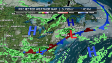
A wet start to Sunday should dry out in northern New England with temperatures in the 70s, however a lighter rain with fog and drizzle may continue for most of southern new England.
Confidence is really low on how our weather is going to evolve later Sunday into Monday. It looks like a flow from the northeast should keep much of southern New England gray, and perhaps wet, while we will warm up and dry out a bit toward the Canadian border.
This next batch of rain may put us over the top for the wettest July on record. As you can see, there’s more wet weather possible next week in our First Alert 10-day forecast.