
Although early clouds and isolated lingering showers Wednesday morning give way to breaks of sunshine, picturesque, puffy clouds will rebuild beneath an energetic disturbance aloft Wednesday afternoon, dragging a cold front through New England at ground level with scattered, renewed showers during the afternoon to early evening.
The new push of cool air will also be drier air, so any scattered showers should melt away after sunset with skies clearing and a cool breeze knocking temperatures into the 30s overnight Wednesday night with wind chill values dropping into the 20s for most of New England!
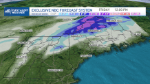
In northern Maine and the Great North Woods of New Hampshire into the North Country of Vermont, air will turn cold enough for rain showers to transition to snow showers, and in the case of northern Maine, a straight-out accumulating snow! In fact, the snow in northern Maine will expand southward through central parts of the Pine Tree State and even into eastern Maine Thursday, accumulating over half a foot in the high country of the northwest part of the state, 3 to 6 inches in the Crown and lesser amounts farther south.
Get Boston local news, weather forecasts, lifestyle and entertainment stories to your inbox. Sign up for NBC Boston’s newsletters.
Elsewhere in New England, the dry nature of Thursday’s air should ensure a dry day, though a cool breeze will continue from the northwest through the day. A cool wind is expected to continue through Friday, too, with a large and stalled storm over Nova Scotia continuing to pinwheel lobes of atmospheric energy over Maine for a few more scattered rain and snow showers, but little more than bubbling clouds with an eastern afternoon sprinkle or shower elsewhere in New England.
The stalled storm over Atlantic Canada actually is a benefit to our weekend forecast in New England, as it will serve to block the normal progression of storms across the remainder of the U.S., all of which will need to slow until that storm departs, meaning renewed rain won’t arrive to New England until next week.
Be prepared for your day and week ahead. Sign up for our weather newsletter.
Weather Stories


That said, after a weekend of building clouds and a sprinkle amid a mostly dry day Saturday, then brighter sky and temperatures in the 60s Sunday, a parade of storms will be set to cross New England next week in our exclusive 10-day forecast.
While it would be silly for us to forecast non-stop rain for five days on end and we certainly don’t want to give that impression, the chance of showers or periods of rain is elevated throughout next week. So while temperatures may rise to or over 60 degrees on a number of days, particularly in southern New England, no exceptionally nice days of weather are standing out right now.
