
When you start your day off in the upper 50s, you know some part of the day is going to be warm. And indeed, that is the case on Wednesday.
Records are likely to be either tied or broken this afternoon; it’s simply a function of sun. If it comes out a little earlier, we’re primed for 70. If it’s a little later, we’ll hit the upper 60s.
“Same difference,” you say. Well, technically it’s the psychological (& climatological) impact of hitting 70 at the tail end of winter that is the underlying point. We’ve only seen it hit 70 in December, January and February fifteen times during our period of record in Boston. (Seven of those have happened since 2001.)

Get Boston local news, weather forecasts, lifestyle and entertainment stories to your inbox. Sign up for NBC Boston’s newsletters.
We typically have two days every winter where we hit 60-plus. So there’s a reason to get worked up over “just” hitting the 60s, or ringing the bell at 70 for the first time since the winter of 2019-20.
In any event, the colder air rushes back in Wednesday night, so prepare for the deep freeze once again. That will keep Thursday nice and quiet before we tackle the mess that is Friday.
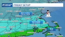
When will it start snowing on Friday?
Snow is expected to break out before dawn on Friday and last through the day and into the night. This is a long storm, but the most intense part will be through the late morning and early afternoon as the storm glides by to the south.
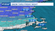
How much snow will we get Friday in Boston?
Weather Stories


We’re minding the warming in the mid-levels of the atmosphere too. That would mean a chance from snow to sleet along and south of the Pike. So from Boston and Worcester south to Taunton and Middleboro, mix will keep the amounts limited to the 6 to 9 inch range.
Where we’re pure snow in northern Massachusetts and southern New Hampshire, it’s a solid 9 to 12 inches. South towards New Bedford and out through the Cape and Islands, we’ll see the possibility of rain mix in at times. Amounts there are down to 1 to 3 inches.
Obviously, travel is a huge headache for the entire day Friday. Slippery roads, clumps of snow, plows all over: expect slow commute times and frayed nerves. Take it slow and easy wherever you may be going. Late night improvements are likely as the storm moves away.
We’ll awake to sun on Saturday for clean-up. Post storm, things look plenty cold. So don’t expect this to vanish in a couple of days. We’ll keep you updated all the way through the event.
