Well, we broke the wet spell with a super summer day yesterday. If you were counting, it was 16 consecutive days of a trace (rain falls, but it isn’t measurable) or more of rain.
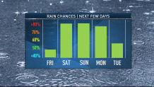
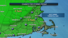
Yes, we’re still in that pattern, and it will become more apparent by the weekend. BUT we have another mostly dry today. The window for thunderstorms will open by 4 p.m. or 5 p.m. in central Massachusetts and shift east to Greater Boston by 5 p.m. to 8 p.m. That buys us a lot of dry hours on this sizzling Friday.
I should be careful using the term dry. Humidity today will be stifling, and there’s not much relief in that department until Sunday. Friday crowds at the beach, and the tide comes in during the afternoon to chase you off the sand in some locations. Water temps are in the upper 60s with a very high UV index.
Get Boston local news, weather forecasts, lifestyle and entertainment stories to your inbox. Sign up for NBC Boston’s newsletters.
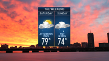
It’s the eve of the weekend, and you’ve probably heard about the threat for storms and rain. It’s confirmed, but Saturday isn’t looking like a complete washout. Some sun is even possible early in the day before we fire the storms up.
Some storms may be strong to severe depending on how much sun we receive. Just be wary of any storms that sweep in from the west in the afternoon. Sunday is the flop of the weekend, with occasional showers, lowering humidity, and a cool onshore wind.
Sadly, the wet weekend kicks off a string of rainy days that go through Monday. Tuesday could see a few storms fire in the afternoon as we emerge from the wet spell. And there’s hope that later next week we could put together more than one or two dry days in a row.
A small shift in the pattern looks like it may be coming, and there’s reason to believe it will end this incessant rain and cool weather. Time will tell. We’ll obviously be all over it. Make it a good weekend!