What a gorgeous St. Patrick’s Day! A day filled with sunshine and mild temperatures with a light wind.
Clouds increase slowly Wednesday night ahead of a storm that is creating severe weather, including tornadoes, across the Deep South. Lows in New England will be in the 30s overnight.
The center of that storm system is going to move into West Virginia Wednesday night and spread rain into New England Thursday. Even though we may begin the day with a few rays of sun, clouds take over mid-morning with rain arriving around midday.
Severe weather isn’t expected here but we will get to see some rain, which will benefit a very dry southern New England. A few areas may get close to an inch.
Get Boston local news, weather forecasts, lifestyle and entertainment stories to your inbox. Sign up for NBC Boston’s newsletters.
Highs should get into the lower 50s before rain cools us back to the 40s.
It’s not only the low pressure tracking to our south -- there’s also a cold front coming from the north. That may bring a little snow to northern Maine early Thursday, but more importantly it’s going to push colder air down south, and we will see rain changing to snow in central and southern New England Thursday night.
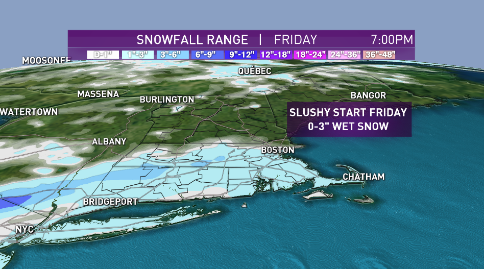
It may snow hard for a few hours just before the sun comes up along and south of the Massachusetts Turnpike.
Some of the hills may get 3 inches of snow, while lower elevations and especially the coast probably end up with closer to no accumulation, but deep slush puddles are possible first thing Friday. Snowfall amounts will depend on the exact arrival of the cold and track of the low-pressure system.
A series of low-pressure systems will track south and east of Nantucket, perhaps keeping the precipitation going on Cape Cod through late morning. It is a moderate nor’easter for southeastern Massachusetts.
The sun should come out in most of New England by lunchtime Friday. Temperatures on Friday will only be in the 30s, with wind gusts up to 40 mph along the South Coast and coastal Maine. It will be a chilly day over the region on the last day of winter, with wind chills in the teens to around 20 degrees for all.
Cold high pressure from Canada will clear out the sky Friday night, with temperature back down to the teens and low 20s.
High pressure comes right over us on Saturday, right on time for the vernal equinox -- also known as the first day of spring. A mainly sunny sky with highs in the 30s to near 40 and a light breeze. A warmer flow arrives Sunday, with highs in the 50s, except coastal towns which may be in the mid-40s.
A warming trend begins Sunday and continues into next week, with most of New England experiencing temperatures in the 50s to low 60s, though slightly cooler at the beaches due to sea breezes, as seen in our First Alert 10-Day Forecast.