
We have another frosty morning out there as temps have dropped to the teens and 20s north, and in the 30s south.
More clouds fill in today south and east as a storm system passes to our south. A northeast wind direction will help trigger ocean-effect rain showers across the Cape & Islands on the northern side of this system.
The wind may gust between 20 and 25 mph, adding to the chill in the air at the coast. Highs today will again be in the 40s with more sunshine the farther northwest you go.
Get Boston local news, weather forecasts, lifestyle and entertainment stories to your inbox. Sign up for NBC Boston’s newsletters.
High pressure remains in control through the weekend and most of next week. So sunshine remains in the forecast for most. High temperatures increase slowly each day, reaching the mid 50s this weekend and then the upper 50s to around 60s next week.
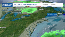
Another storm system passes way to our south Sunday into Monday and, for now, the forecast models agree it will stay far away. However, some increased splashover will occur along the coast as our wave heights increase to 3-6’ by Sunday.
Tides are running astronomically high due to the new moon on Thursday. So any little wave action will add to the water on shoreline roads on either side of high tide Friday, Saturday, Sunday, and Monday around noon time.
Weather Stories


Our next widespread chance for soaking rain won’t be until the end of next week. Enjoy this nice, quiet stretch!
