A cold front approaches Boston this morning, and showers and isolated t-storms are ongoing as the rush into work is underway. Watch for some brief heavy rain and gusty wind through mid-morning. Late morning, these showers head offshore and we see temps quickly rise once the sun pops out.
A stray pop-up shower or storm will be possible through sunset still as the cold front moves through. High temps reach the low 80s to 70s at the coast with a light sea breeze. The humidity lowers late in the evening.
By Tuesday, we dry out with full sun and the humidity is long-gone behind the cold front and as high pressure returns. Highs will be a touch cooler but in the 70s. Even cooler air is around for Wednesday with more sun and highs in the low 70s.
Thursday and Friday our humidity is on the rise and so are our temperatures. We reach the low 80s for the first round of tournament golf in Brookline, Massachusetts, for the U.S. Open on Thursday. We stay dry until Thursday night as a cold front approaches the northeast. Stay tuned to rain timing as this can certainly change.
Get Boston local news, weather forecasts, lifestyle and entertainment stories to your inbox. Sign up for NBC Boston’s newsletters.
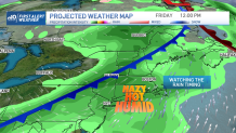
For now, the storms and showers move through overnight and linger Friday afternoon. Highs will be in the mid to upper 80s Friday and muggy before the front moves out that evening.
Showers may linger as another shortwave passes through New England early, most of the day is dry. High pressure takes over for the majority of Father’s Day weekend as sunshine returns and highs in the 70s. Picture-perfect for any outdoor plans, especially Sunday!
Next week there is a chance for a big warm up on the way…80s to low 90s, but since this is 8-10 days away, we will keep watch on that.