
The weather break continues for more storm cleanup and power restoration in southeastern New England.
Cool temperatures are found everywhere, with frost inland and north and west. Temps don’t warm up much this afternoon with highs in the 50s for all. More sun is expected again north and west, while south and east the stubborn clouds hang on as our nor’easter exits far east and another low pressure system heads in.
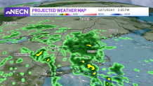
Tonight a few showers head into southwestern and western Massachusetts and Connecticut. The rain spreads northeastward during Saturday morning and afternoon. Off and on rain or showers continue for New England all day and night.
Get Boston local news, weather forecasts, lifestyle and entertainment stories to your inbox. Sign up for NBC Boston’s newsletters.
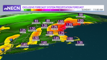
This storm is not expected to head offshore or blow up into a major nor’easter. We will see 1-2” of rainfall, which could lead to some ponding and flooding near storm drains blocked by debris or leaves.
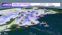
Wind gusts from the east will be up to 20-30 mph inland Saturday evening and night, and around 40 mph at the coast. With the gusty wind and rain impact, we added a First Alert for Saturday.
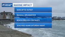
Wave heights will increase just a tad with this storm, to 8-13 feet. More beach erosion, and splashover along seawalls will occur during the high tides.
Halloween still looks mainly dry, but a few showers could certainly linger early in the day. Trick-or-treating in the evening will be generally dry with seasonable temperatures in the 50s.
We remain quiet to begin the month of November with more normal temperatures in the 50s. A couple systems move in, one around Wednesday, and another of the end of the week. No major storms or other First Alerts are on the 10-day.
