
We saw a decent late winter day across the six state region Saturday with temperatures reaching the low 40s south, the 30s north, with some high thin clouds dimming out the sun ahead of a warm front.
That warm front will push through the region tonight with the slight risk for a rain/snow shower south, better chance for snow and sleet across central and northern New Hampshire into northern Maine overnight into the early hours of Sunday morning where we could see a coating to an inch or so of snow.
Winds will also start to increase out of the southwest overnight with slowly rising temperatures. Lows tonight bottom out in the low to mid 30s south, 20s north, and teens far northern Maine.
Sunday will feature gusty winds out of the southwest along with very mild temperatures pushing the low 60s south, low 50s north, near 40 northern Maine.
Get Boston local news, weather forecasts, lifestyle and entertainment stories to your inbox. Sign up for NBC Boston’s newsletters.
We’ll also have to deal with some showers, especially from the late morning into the early afternoon hours as low pressure passes to the north of the region.
With cold air still in place across northern Maine, we’ll still be seeing snow and some mixed precipitation there through around noontime, eventually changing to a cold rain by the mid-afternoon.
By Sunday evening, more rain showers break out across northern New England and track into southern New England during the first portion of the night as a cold front slides through the region. That’ll help usher colder air back into the north, but we remain mild south.
On its heels Monday, yet another area of low pressure will move through the region. With that cold air spilling back into northern New England, it’ll most likely be snow there much of the day with several inches possible.
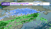
Central and southern New England are looking too mild to support snow at this time which is why we’re forecasting a rain event, but we’ll watch to see if the track of the storm changes in upcoming model runs.
Local
In-depth news coverage of the Greater Boston Area.


The rest of next week is looking a bit warmer than average with the next shot for rain or snow arriving later in the week.
