
This is the rougher side of autumn in New England. Fog, mist, downpours, wind and raw temperatures. While we’ll have frequent breaks from all of these elements Wednesday, it’s still a substandard day in terms of the best that October has to offer.
Some spots may close in on 3 inches of rain on the South Shore, as what remains of our coastal storm slowly moves out to sea. Most other spots will have a hard time getting to – or even surpassing – 1 inch of rain. The random nature of the downpours and showers means that at times we may have an opportunity to dry out for a spell – especially in the latter half of the afternoon. Winds won’t be howling, but will be up just enough to be pesky or even invert some umbrellas if you’re at or near the coast.
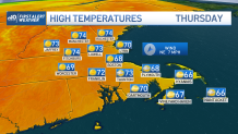
Last bits of wet weather will pull away Wednesday night. Clearing will reach in from the north as we return to sun Thursday. Highs leap back to the 60s – or even low 70s northern Massachusetts and southern New Hampshire. And that’s just the start of the warmer weather. Friday’s highs will push the mid-70s in many areas.
Get Boston local news, weather forecasts, lifestyle and entertainment stories to your inbox. Sign up for NBC Boston’s newsletters.

It all comes crashing down by the weekend. Cooler air moves in with a front on Friday night and highs slump back to the upper 50s to near 60 for a dazzling Saturday and Sunday.
