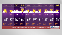
After several wet days in a row, sunshine is in the forecast for the most part of today and tomorrow.
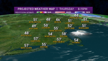
The weather systems that impacted us so far this week delivered a good dose of rain. Some areas picked up more than three inches this week and six inches since last week. That front is now stalled just to our east with several low pressure systems riding up, mostly just missing us to the east and north.
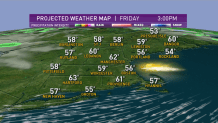
A small high-pressure system tracking south of New England gives us dry air with a mix of sun and fair weather clouds today and tomorrow, temperatures mostly in the 50s north to low 60s south. Wind from the northwest may gust past 25 miles an hour for a while this morning, diminishing this afternoon.
Get Boston local news, weather forecasts, lifestyle and entertainment stories to your inbox. Sign up for NBC Boston’s newsletters.
With a clear sky tonight we should experience radiational cooling. Many areas may cool into the upper 20s to low 30s with scattered frost in the normally colder spots, most of us are going to be in the low 40s.
Tomorrow looks like a carbon copy of today with sunshine and a little bit less wind.
Our plot thickens for the weekend. There’s going to be an ocean storm that may clip Cape Cod and eastern Maine with rain and wind. Meanwhile, there’s a front moving out of New York into western New England with a strip of showers or some rain possible. Timing and placing each of these systems is still a bit in question.
Also it’s cold enough that some of our tallest mountains may wake up to some snow for the second Saturday in a row.
On Mother’s Day, it looks like we may thread the needle between wet weather to our north, to our west, to our south, and to our east. Hopefully we get a nice bit of sunshine, especially late morning to early afternoon with temperatures topping 60°.
Next week looks mostly fair and cool for a few days, before more wet weather returns late in the week, as seen in our First Alert 10-Day Forecast.