Some seasonable, quiet weather welcomes us into this work week. High pressure brings in a northwesterly flow for today with a gusty wind in the heat of the afternoon.
The very low humidity, dry brush, and gusty winds lead to an elevated wildfire risk in southern New England. In northern New England, we have upslope wind providing some light snow showers in the mountains.
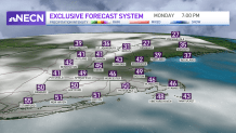
Highs today reach the 40s north and 50s south, and this is our mildest day of the week. We stay breezy again tonight into tomorrow with a clear sky.
Sign up for our Breaking newsletter to get the most urgent news stories in your inbox.
Get Boston local news, weather forecasts, lifestyle and entertainment stories to your inbox. Sign up for NBC Boston’s newsletters.
The mountain snow showers taper early Tuesday and we are left with a couple inches of snow. Lows drop to the 30s south and the 20s far north.
We will be slightly cooler for Tuesday with the continued northwest flow and a gusty wind. Highs still reach the 30s and 40s north, to the 50s south.
Clouds increase for Wednesday but we keep it dry until evening, as our next storm system heads in from the west. A light wintry mix in the mountains will change to rain by Thursday as this low pressure system heads northeast.
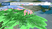
Thursday will be a rainy day for all with steady waves of rain for all of the northeast. Temps stay in the 40s to 50s through that storm and into the weekend.
The shower chance may not head out until the following week, meaning we keep a slight chance for rain in both Saturday and Sunday. Stay tuned as we iron out the daily details.