Temperatures continue to slowly rise even though we're also going to see those earlier sunset times. Highs today will be in the 50s to low 60s with plenty of sunshine as high pressure continues to dominate our weather pattern.
With this warm up, even our overnight lows will be milder. Low 40s for many places at the coast and south, with still 30s and frost inland. Tuesday will run about 5-10 degrees warmer than normal as highs soar to the 60s. The day will be mostly sunny with a few clouds heading in late.
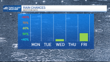
A weak, low-pressure system brings in a weak cold front for Wednesday morning, so a couple showers are possible with more cloud cover. After the frontal passage, our highs lower a tad to the 50s Wednesday afternoon and for Veterans Day on Thursday.
We see another small warm up as temps return to the low 60s for Friday into Saturday. However, widespread rain also returns to the northeast. Our wind increases a bit as heavy rain heads in Friday night into Saturday. Rainfall amounts around 1” will be possible. We cool to the 40s to around 50 by Sunday as we dry off.
Get Boston local news, weather forecasts, lifestyle and entertainment stories to your inbox. Sign up for NBC Boston’s newsletters.