Get ready for a powerful backdoor cold front which will trigger a significant drop in temperatures.
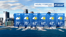
Before that, it’s warm and muggy to start out Tuesday, with temperatures in the upper 70s with dew points in the lower 60s. As the cold front pushes through this morning, temperatures will drop considerably to the 60s by mid to late morning.
Winds will pick up with strong gusts, making these cool temperatures feel even cooler. As the day progresses, dew points will drop to the lower 50s and temperatures will remain cool through Wednesday.
Get Boston local news, weather forecasts, lifestyle and entertainment stories to your inbox. Sign up for NBC Boston’s newsletters.
Inland locations will still reach the mid 80s to 90 during the afternoon with a few showers and thunderstorms popping up later in the day and evening.
By Wednesday, all of New England cools off under mostly cloudy skies as a wave of low pressure moves through the region bringing some beneficial rain showers along with some thunder that lasts into Wednesday night. These thunderstorms promise to pack a punch but not severe, for now. We do expect gusty winds and small hail from these cells.
Thursday will remain mostly cloudy with cooler than average temps along with the threat for afternoon showers. More rain showers possible again Friday, but we’re seeing a bit of uncertainty as for the timing as another wave of low pressure moves through the region.
Weather Stories


As for the weekend, we’re expecting pleasant conditions with a more seasonable feel.
Meanwhile, enjoy the heat inland and fall-like feel along the coast.