
The nuisance wind this evening isn’t too strong, but it does add to the chill and helps to bring in colder temps overnight.
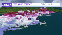
Cold with biting wind chills Friday
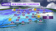
Lows tonight drop to 0-10 degrees, city centers in the mid teens, and far northern New England below zero. Wind chills near the Canadian border will be -20 to -30 degrees by Friday morning. Highs on Friday barely reach the 20s to near freezing. The wind does relax a bit and it will be sunny. A couple flurries linger in the mountains. Good news for spring-lovers, Friday is our coldest day for a while.
Get Boston local news, weather forecasts, lifestyle and entertainment stories to your inbox. Sign up for NBC Boston’s newsletters.
Mild Saturday, and temps could hit the 60s Sunday
Milder air begins to take hold on Saturday with highs becoming more seasonable in the 40s. Scattered showers head in for late Saturday and as this pushes northeast overnight, we see more warmth for Sunday.
The wind turns gusty from the south and this allows highs to reach the 50s to 60s south. Northern New England will see a wintry mix Saturday night into Sunday, changing to light rain showers Sunday off and on. Farther south, there will be breaks in the rain to enjoy the spring warmth. Then more showers develop by afternoon to evening, but not expected to be a washout day.
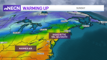
Another system lifts northeast Sunday into Monday, bringing in more rain shower chances. Temperatures next week consistently stay milder, with highs around 50 throughout next week.
