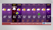
We’ve seen plenty of melting today with our highs reaching the upper 40s and 50s today.
Temp drop overnight brings black ice, slick roads
Much of that moisture will refreeze overnight as our lows drop to the 20s in central and northern New England, allowing for black ice to form and bringing slick spots in our roads. Plan ahead and take it slow in the morning. Patchy fog will also form along southern states bringing our visibilities down to less than ¼ of a mile in some areas.
In the afternoon we’ll see more passing clouds. No precipitation will be expected south but isolated and light snow showers will pop up in the northern country right near the Canadian border along northeastern Vermont, New Hampshire and Maine.
Get Boston local news, weather forecasts, lifestyle and entertainment stories to your inbox. Sign up for NBC Boston’s newsletters.
Temperatures will rise again to be mild, climbing to the upper 40s and 50s again.
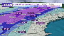
Another storm brings rain and snow Saturday
But our next storm arrives Saturday; the snow begins early in the morning across the northwest, where the highest snowfall amounts will add up over 8", isolated spots will even see a foot of snow. The rain also begins early but in the far southeast, growing rain coverage will spread farther into Connecticut, Massachusetts, southeastern New Hampshire and Maine by late morning before the snow takes over as temperatures drop in the evening.
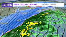
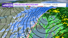
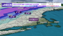
As the snow pushes south, our moisture is likely decreasing, for which snow accumulation amounts will be limited in the south, but rainfall amounts may add up to 1" in some areas. Embedded downpours are expected with this system before the snow replaces the rain late Saturday. From a coating to 2” will fall after the rain on Saturday night in the south. Wind gusts will exceed 35 mph and may reach up to 50 mph, strong enough to cause power outages.
Our system moves out by the end of the night and sunny skies will brighten our day on Sunday. It's going to be a clear but cold afternoon. Our morning will feel like the single digits south and below 0 north. While in the afternoon we'll continue to feel wind chills in the teens north to the 20s south. We'll quickly turn the page to spring as we climb our way up to the upper 50s and 60s next week.
Take a look at our Exclusive 10-day forecast and plan ahead with your NECN & NBC10 Boston First Alert Team.