
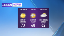
If you enjoyed Wednesday afternoon’s weather then you’re in for a treat again Thursday. High pressure is in control and it’s here to stay for a couple more days.
Our temperatures will cool after sunset and continue to drop into the 40s and 50s overnight under clear skies. We’ll rebound quickly Thursday thanks to ample sunshine -- expect highs of 70-75 for much of the region.

A backdoor cold front will slide from Maine down to the New Hampshire seacoast and North Shore of Massachusetts late Friday, accompanied by a strengthening northeast wind, some low clouds and cooler air. There may be a sprinkle or two along this boundary, but nothing more than that.
Get Boston local news, weather forecasts, lifestyle and entertainment stories to your inbox. Sign up for NBC Boston’s newsletters.
We’re on the cooler side of this front on Saturday, so highs will be about 10 degrees cooler, in the lower 60s.
We’ll moderate again by Sunday and Monday (mid 60s to near 70) under lots of clouds, some breaks of sun and mainly dry weather. We still can’t rule out a few showers on Sunday in northern New England and on Marathon Monday, but it’s a low risk.
Weather Stories


Much of next week features seasonable temperatures and quiet days with the greatest chance of some passing showers on Wednesday. Our exclusive 10 Day Forecast features no significant storms, no big-time warm ups and no abnormally chilly days either.
