
Wednesday is the last day of gloomy, raw, showery weather in this stretch for New England. Largely the result of a stalled coastal storm off the Mid-Atlantic coast and the product of a last vestige of atmospheric energy from once-Hurricane Ian, New England’s northeast wind, gusting at times to 35 mph at the coast Wednesday, not only keeps clouds and periodic rain in the forecast, but keeps waves churned and hold temperatures shy of 60 degrees for most.

As the storm to our south finally drifts east and away overnight Wednesday night into Thursday, the wind direction will shift and that will mark the start of new weather. Showers taper overnight and early clouds Thursday with a sprinkle on Cape Cod breaks for increasing sun and a light northwest wind that will aid in drying the air, gently sloping down off the hills and mountains of northern and central New England.
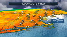
Temperatures will respond to the emerging sun, warming into the 70s for many. Another mild day is expected Friday with a predawn shower possible associated with a final push of warmth, then an evening showers possible with a passing cold front, but much of the day will be breezy, bright and beautiful with high temperatures in the 70s.
Get Boston local news, weather forecasts, lifestyle and entertainment stories to your inbox. Sign up for NBC Boston’s newsletters.
Behind Friday evening’s cold front, new, cool, autumn air arrives for the weekend, delivering fair sky and dry weather, but cooler-than-normal temperatures in the 50s both Saturday and Sunday by day, and cold enough for frost at night in northern, central and sheltered valleys of interior southern New England.
Although fall air remains in place all of next week in our exclusive, First Alert 10-day forecast, right now the week looks fairly close to normal for this time of the year, with the highest chances for passing showers on Tuesday and Thursday ahead of quick-moving cold fronts.
Weather Stories


In the Tropical Atlantic, there are a couple of areas of likely development in the coming days, but none with any imminent or foreseeable threat to the U.S., with one disturbance moving west to east just off the South American coast and the other in the Eastern Atlantic but predicted to remain there.
