
It’s been a somewhat cool day, although pretty close to normal for this time of the year. Our highs have mostly remained in the mid and upper 40s with some lucky 50s far south. Our skies began sunny and now we see some more clouds filling in from the west.
Rain moves in overnight
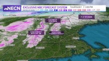
Our dry stretch is now coming to an end. We’ve got showers on our doorstep, they move in overnight and arrive to western New England first. A winter weather advisory will go into effect at 10 p.m. this evening and last through noon Thursday. This will include from northern Worcester, Massachusetts to western Franklin County, Massachusetts to western Hampshire county, Massachusetts and most of Vermont and New Hampshire. It will be an overall day event for which our morning and evening commutes will be impacted.
Get Boston local news, weather forecasts, lifestyle and entertainment stories to your inbox. Sign up for NBC Boston’s newsletters.
We’ll have different types of precipitation: sleet/freezing rain, rain and snow. The ice is likely staying near and above 1000 ft of elevation. Total ice accumulation amounts could add up to 1/10th of an inch in some areas. The Berkshires will be one of the first ones impacted as soon as tonight, the rain reaches western New England around 11 p.m. today as well and the green mountains watch for sleet/rain filling in from north to south.
Icing possible at higher elevations
Weather Stories


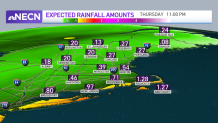
The wintry precipitation becomes more widespread by 5 a.m. and reaches the white mountains in New Hampshire and Maine. Unlike Vermont and New Hampshire, Maine has higher chances of having snow early morning. The snow will shift towards Presque Isle closer to noon. The rain and sleet will take over half of Maine and the rain will continue from Central New Hampshire to the south and southeast. Embedded downpours will be possible along this system in the southern states. Total rainfall amounts could exceed or near an inch in the most affected areas, especially in the far south. The rest will likely add up about 3/10th of an inch.
Strong wind gusts
Winds will pick up by 3 a.m. in western Vermont and pick up in velocity in northern NH by noon. The cape will also go through wind gusts ranging from 35-45 mph. New England waters will see waves ranging from 5-11 ft; first in the south shores by late morning and then making their way up to the north shores by tomorrow night. A small craft advisory will remain in place through 8 a.m. Friday and the Gale warning in the south shores will remain in effect through 8 p.m. Thursday.
Warmer temperatures Friday
While Friday is starting up with morning snow showers in the Canadian border, our southern states will watch for mostly sunny skies and the warmest temperatures of the week; highs in the upper 50s with some 60s along the far south. Precipitation chances will return Friday evening for the mountains.
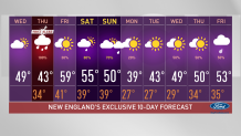
This weekend features scattered showers for northern and western New England once again but the exact timing and locations are not yet pinned down. Stay tuned to our First Alert Team on NBC10 Boston and NECN for all the updates. Drive safe.
