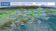
That nice high-pressure system that we had since Sunday is gone too far out to sea now. The return flow is bringing back very humid weather with a chance of a few showers and thunderstorms today.
The big ticket item though is tomorrow, when the remnant of tropical storm Fred will traverse New England.
For now, it's a weak boundary in northern New England this morning, but it did result in some flash flooding in parts of New York yesterday. It does not take much energy this time of year to produce some heavy rain.
Get Boston local news, weather forecasts, lifestyle and entertainment stories to your inbox. Sign up for NBC Boston’s newsletters.
We may have some isolated downpours and spotty severe thunderstorms across parts of Vermont, New Hampshire and Maine this afternoon, pressing south towards northern Massachusetts by this evening.
The sun is shining though at some of the beaches, especially from Cape Cod and the Islands west to the Connecticut coast. Parts of northern Maine are also having a pretty nice day. But for most of us, it’s mostly cloudy and sticky with temperatures well into the 80s, a few spots could touch 90° with enough sunshine.
The remnant of Fred is moving across West Virginia into Pennsylvania this afternoon with a continuation of very heavy rain and severe weather. There was disastrous flooding in western North Carolina last night, where five to eight inches of rain fell in a very short time.
Rain will work into southwestern New England this evening from Fred, otherwise scattered showers and thunderstorms possible due to a front that stalled here. Very sticky tonight with a low temperature in the 70s.
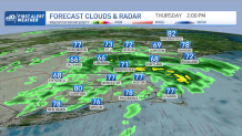
The track still remains somewhat uncertain, but along and just north of the center of whatever is left of Fred in New England tomorrow, we may see rainfall amounts in excess of three inches with localized flash flooding. There’s also the possibility of a few severe thunderstorms.
Weather Stories


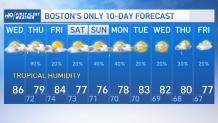
The least amount of rain tomorrow looks like southeastern New England and far northern Maine. With tropical humidity, high temperatures are going to be in the 70s to low 80s. Friday is looking a little better with a return to partly to mostly sunny skies. It'll be warm and sticky with a high temperature in the 80s.
The plot thickens again for this weekend, tropical cyclone Henri is expected to be a hurricane within a few hundred miles of our south coast Saturday night and Sunday. At the same time we have a backdoor cold front coming from Maine to Massachusetts.
Otherwise it’s warm and sticky in the rest of New England and all these subtle boundaries will create showers and the possibility of a thunderstorm. The track of Henri is not a done deal and bears a close watch. Stay tuned to our first alert 10-day forecast for the latest updates in this very volatile weather situation.