Awesome summer weather just keeps rolling on. Most of today will fall under that umbrella (for lack of a better term), but there are a few storms we have to take note of this afternoon.
The line will march out of eastern New York with lots of vim and vigor, possibly triggering warnings for strong winds and hail in the Berkshires, the Pioneer Valley and outermost Rt. 2.
Timing puts these storms in western New England in the early afternoon, with storms approaching Greater Worcester in the mid-afternoon and Greater Boston in the late afternoon.
Our weather team issued a First Alert Tuesday for storms developing between 3 p.m. and 10 p.m. The threats would be lightning, hail and damaging wind worst-case scenario. The wind could gust upwards of 40 mph but as they approach Boston they run into more stable air and completely fall apart.
Get Boston local news, weather forecasts, lifestyle and entertainment stories to your inbox. Sign up for NBC Boston’s newsletters.
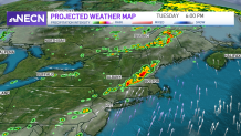
The best lift and instability will remain west of Worcester throughout the day, lowering the chances of severe weather inside I-495. That said, we’re all at risk for a summer storm, even down to the South Shore.
Sadly, not everyone is going to get the water they want or deserve. It’s good to remember that most of the water from storms ends up as runoff, so this will NOT be a drought-buster or a pattern-changing event.
We’ll see both wind (nothing new) and humidity crank up today. Some relief in both departments tomorrow, but the humidity comes roaring back for the remainder of the week and the weekend. Seems there will be no shaking that anytime soon.
Get updates on what's happening in Boston to your inbox. Sign up for our News Headlines newsletter.
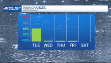
With a front stalling across eastern Massachusetts in the coming days, we may get a pop-up storm each afternoon along with the sea breeze. Again this promises to leave a lot of communities with “rain envy," but I suppose it’s better that someone gets a watering than we all go dry.
Keep your eyes peeled for storms this afternoon!