Our First Alert weather team has kept an eye on the busy Tropical Atlantic for several days, but now two tropical systems are making their way into our forecast.
First, the remnant moisture of once-tropical storm Fred has been expanding across the northeast. While most of the rain Wednesday is focused from the Appalachian Mountains to Pennsylvania and upstate New York, showers and periods of rain are expanding east across northern New England. An occasional shower will impact southern New England Wednesday, particularly during the afternoon.
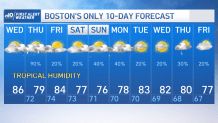
With a steady south and southwest breeze, humidity is on the rise Wednesday. Even with plenty of clouds and only breaks of sun, temperatures are rising into the 80s.
While more downpours join the showers in northern and central New England overnight Wednesday night, the bulk of New England’s rain will fall Thursday.. Expanding from west to east during the morning, the rain will arrive at the Cape and eastern Maine last, around midday and afternoon, respectively.
Get Boston local news, weather forecasts, lifestyle and entertainment stories to your inbox. Sign up for NBC Boston’s newsletters.
Our weather team has issued a First Alert for potential impact of downpours and thunder Thursday, slowing travel and perhaps resulting in localized flooding, particularly in parts of northern and western New England. Showers and downpours will break into scattered form later Thursday.

Friday will likely bring a relative pause in the action with only a few showers but breaks of sun. The humid air will bump temperatures between 85 and 90 degrees during the afternoon! The next storm approaching New England brings an increasing chance of showers Saturday, especially during the afternoon, while humid air persists all the way into next week.
Weather Stories


The biggest issue in our forecast focuses on Sunday and Monday, when Tropical Storm Henri, south of Bermuda as of Wednesday morning, is predicted to strengthen to a hurricane over the warm Gulf Stream waters and turn northward, paralleling the East Coast. The key to our Sunday and Monday forecast hinges on how our incoming storm from the west interacts with Henri.
The most likely outcome is for Henri to get a bump toward the northeast as our storm approaches, causing the hurricane to deflect out to sea to our southeast but likely throw building swell into our coastal waters and a rip current to our beaches. If our incoming storm is slow enough, and just the right strength, it will fail to boot Henri out to sea and instead the two systems may merge, pulling the hurricane close to or perhaps even over New England.
Although this worst-case scenario is unlikely at this point, it’s not impossible. That’s why both Chatham and Nantucket were in the forecast cone of probability from the National Hurricane Center on Wednesday morning for a possible center-passage Sunday into Monday.
Later on in the day, the storm's projected track shifted slightly farther west, putting Boston within the cone of probability. Another shift of the projected track put all of Massachusetts in the cone by Monday morning, though Henri could still end up far out in the ocean. We'll be monitoring the upcoming updates from the National Hurricane Center for more.

For now, our First Alert forecast acknowledges this potential but follows the most likely scenario of building four to six foot seas, strengthening beach rip currents, rain due to the incoming storm from the west, but a passage of Henri and its wind core to our southeast. Regardless, humidity will linger until midweek next week in our exclusive First Alert 10-day forecast.