Saturday was a quiet and cold day, with a ton of sunshine across the region and highs in the 20s south, upper teens to mid 20s north.
The sky will stay mostly clear through the first half of the night, allowing temperatures to cool off quickly, with light winds and dry air and, mostly importantly, a blanket of snow on the ground! Lows will fall into the teens and single digits north, teens to low 20s south.
This will set the stage for a system approaching from the west, which will track north of New England during the day Sunday, bringing slightly milder conditions with it.
Get Boston local news, weather forecasts, lifestyle and entertainment stories to your inbox. Sign up for NBC Boston’s newsletters.
However, with cold air in place, we will see mixed precipitation develop as the milder air overruns the cold air early Sunday morning into the afternoon.
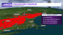
Currently, we’re expecting light snow, sleet and freezing rain to break out across western Connecticut, interior Massachusetts, southern Vermont and southwestern New Hampshire by daybreak and continue into the early afternoon. With a light glaze to less than a tenth of an inch of ice accretion, we could see icy conditions develop.
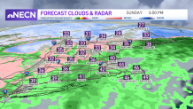
Eastern areas of Massachusetts may see some snow/sleet at the onset, but mild air should win out by late morning as temperatures rise through the 30s.
Further north into New Hampshire and Maine, snow and sleet showers are expected much of the day, with temps holding in the 30s for highs. A light accumulation of snow is likely, with an inch or so possible, especially across the northern mountains of New Hampshire, Maine and Vermont.
Conditions improve overnight Sunday night behind a cold front that ushers in more seasonable air for Monday, along with gusty winds. Highs reach the upper 20s south, low to mid 20s north.
An arctic frontal boundary arrives late Monday and, behind it, we’ll see the coldest air of the season, so far, by Tuesday morning! It’ll be dangerously cold, with highs barely breaking into the teens south and in the single digits north -- the wind will make it feel much colder than that!
We issued a First Alert for Tuesday due to the extreme cold conditions! Do your best to stay warm by dressing in layers and not staying outside too long if you don’t have to.