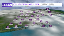
Our weather really got it together for the second half of the day today! We broke out in sunshine and our temps jumped quickly. Tonight’s lows will be in the 40s and 50s as more thin clouds head in.

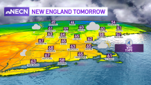
A warm front moves in for Wednesday, bringing a few showers across northern New England. Southern New England will see more clouds around and temperatures in the mid-60s. With a cool south wind at the coast, the south coast will stay in the 50s. Wednesday night with the warm front around we will keep an eye out for a couple thunderstorms.

Get Boston local news, weather forecasts, lifestyle and entertainment stories to your inbox. Sign up for NBC Boston’s newsletters.
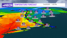
A frontal boundary (backdoor front) moves backward towards southwestern New England onshore on Thursday. This means more clouds and showers around but also a huge spread in high temperatures. For example, Hartford may reach 72 degrees (perhaps an 80 somewhere in the Connecticut River Valley) while Boston may be stuck in the upper 50s. This depends on how far inland the boundary pushes. Thursday afternoon more showers and thunderstorms move through, some could produce strong gusty winds in western New England where temps are much warmer.

Friday morning showers clear out in time for the Red Sox Home Opener. The weekend is split again with warm and a couple of showers Saturday (60s) and a chance for early showers Easter Sunday, breezy and cool in the 50s. We are keeping close watch on Marathon Monday as showers may head in late into Tuesday and highs in the mid 50s. Most of the race seems to be dry, but stay tuned for timing updates as we thread the needle between two systems.

