
The coldest point of this week is in the past as we hit lows below zero in many places this morning.
Tonight will still be cold, but technically "milder." Our lows drop to around zero north, and around 10-20 degrees south. With a clear sky and our full moon (full officially Thursday at 11:57 a.m. the “snow” moon), it will be a bright night.
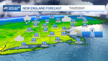
Our wind direction flips from the southwest by tomorrow morning and this means the start of a warm-up. Highs will be in the 40s as the snow really melts away in southern New England tomorrow. As the southwest wind transports more warmth our way on Thursday, we could make another run at 60 degrees in Boston.
Get Boston local news, weather forecasts, lifestyle and entertainment stories to your inbox. Sign up for NBC Boston’s newsletters.
The wind could become pretty strong from the southwest Thursday night into Friday morning. In fact, it will be damaging and enough for a First Alert Friday morning.
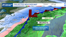
Gusts of 50-60 mph are possible, then up to 70 mph on the outer Cape, plus rain for the Friday morning drive. Power outages and scattered damage are likely around southern New England between roughly 9 p.m. and 6 a.m. Friday. And a couple of rumbles of thunder may also be possible as the cold front sweeps through Friday morning around sunrise.
Weather Stories


After the rain moves out Friday afternoon, we see temps fall a bit to the 40s with a gusty westerly wind. Gradually temperatures continue to fall for this weekend. Highs on Saturday will be in the upper 30s and Sunday around 40. Not too bad for the weekend, and we expect a quiet forecast with sunshine on both days.
