Pleasant and comfortable air is entrenched regionwide in New England Thursday, but that doesn’t stop the puffy, cumulus clouds from developing.
In addition to making a picturesque blend with sun at times and blotting out the sun at others, some of these fair weather clouds grow large and heavy enough to drop a few stray sprinkles Thursday afternoon across interior New England. Nonetheless, the comfortable air will remain in place Thursday evening and night under variable clouds. Then we will have a meaningful shift in wind direction Friday.
After a south-southeast wind Thursday into the evening, a southwest wind takes over Friday, which does two things: 1) transports warmer air into New England and, 2) diminishes the cooling impact of the ocean for all by south-facing coastal locales. The result will be a return to daytime high temperatures well into the 80s and building humidity, particularly in Southern New England and especially in the afternoon.
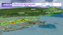
There are two possible triggers for showers and thunder Friday. Thankfully they don’t line up for a widespread and significant event, instead coming through separately.
Get Boston local news, weather forecasts, lifestyle and entertainment stories to your inbox. Sign up for NBC Boston’s newsletters.
In the late morning through early afternoon, a weak disturbance aloft ripples overhead at the jet stream level, prompting clouds to build and some isolated or widely scattered showers to develop. By late afternoon to evening, the cold front at ground level swings from north to south across New England.
This means new widely scattered to scattered showers and thunderstorms are a possibility until the front clears off the New England coast Friday evening, opening the door to yet another fresh installment of dry and pleasant air that will last through the weekend.
Get updates on what's happening in Boston to your inbox. Sign up for our News Headlines newsletter.
Thousands of feet above our heads, the change in air actually may take several hours longer, which is why some clouds will probably linger over most of southern New England Friday night and near the South Coast including the Cape and Islands Saturday morning. But even those clouds should press south by Saturday afternoon, affording sunshine regionwide that will last through Sunday, Monday and into Tuesday.
An onshore wind from the northeast and east both weekend days will mean high temperatures in the 70s at the coast and just over 80° inland. A wind shift to blow from the south and southwest Monday into Wednesday will mean more widespread warmth well into the 80s and even 90s for some. Gradually increasing humidity will be particularly noticeable by Tuesday and Wednesday, priming the atmosphere for an increased chance of thunderstorms.
As the next cold front and upper level disturbance approach simultaneously at midweek, thunder will become more likely in northern New England Tuesday, then for most of New England Wednesday and Thursday, with a chance of scattered showers or thunder lingering into next weekend.