Fog, drizzle, and low clouds have given us a gloomy and chilly start to the day. As the clouds erode this morning, sunshine will help boost our temperatures even at the coast.
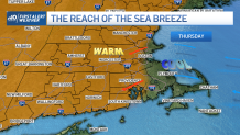
Sea breezes kick in eventually, so in Boston and across Cape Cod highs reach the 60s. Compare that to inland, where highs soar to the 70s and 80s with full sun.
Valleys will become downright hot today as highs reach the mid 80s across the Champlain River Valley, low 80s in the Connecticut River Valley. Overnight we again see fog head in from offshore, more low clouds and drizzle near the coast.
Get Boston local news, weather forecasts, lifestyle and entertainment stories to your inbox. Sign up for NBC Boston’s newsletters.
Our wave heights continue to diminish as the northeast wind goes away and as the coastal storm off the Carolinas dissolves. The brush fire risk remains really high in northern New England, to elevated in southern New England through Friday.
Some showers head in for Saturday into Sunday and for mainly interior spots. Widespread rain for all holds off until a cold front moves through the northeast for the start of the week. The pollen count also remains very high through the weekend.
Get updates on what's happening in Boston to your inbox. Sign up for our News Headlines newsletter.
Friday into the weekend the warm temps take over at the coast, too. Highs will be in the 70s to 80s, with cooler temps at the south coast with a south wind. Again, it won’t be a washout this weekend, but some showers may pass through from time to time.
The humidity rises for Saturday and Sunday with dewpoints in the 60s. Overnights will be muggy and warm with lows in the 60s. Cooler temps seem to head in for midweek next week, but still in the 60s to 70s across New England.