Tropical storm warnings were expanded to include much of Massachusetts, Rhode Island and Connecticut Monday as the region braces for impacts from Tropical Storm Isaias later this week.
The warnings included the Boston area, Middlesex County and Cape Cod and Nantucket. They also includes Worcester and other counties.
For a complete list of Tropical Storm Warnings in the area, click here.
In Rhode Island, Bristol, Providence, Newport and other counties are under tropical storm watches, as are New Haven, Hartford and other counties in Connecticut.
Many other New England counties are under tropical storm watches, including Berkshire County, which saw a tornado touch down during storms Sunday.
The warnings were issued after the National Weather Service issued tropical storm watches for Mass., RI and parts of NH, and a tropical storm warning for parts of Conn. earlier.
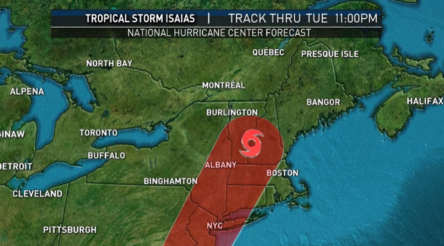
Tropical Storm Isaias is expected to hit New England Tuesday, threatening to carry heavy rain, damaging wind gusts from 40 to 60 mph and a high risk of rip currents at south coastal beaches for about a six-hour time period.
Meanwhile, our humidity will very slowly decrease over the course of the day Monday, limiting the heat index value but not stopping a rise in temperatures to around 90 degrees by afternoon. Aloft, there’s really no significant trigger to touch off thunderstorms, so a storm-free day is expected for most of New England.
Just to our south, tropical storm Isaias continues to churn and slowly move northward toward the southeast U.S. coast. The sooner Isaias makes landfall in the Carolinas – and the longer the storm spends over land as it moves north – the better the outcome for New England.
In fact, by the time Isaias arrives to New England and makes a pass over western New England, it’s likely to carry heaviest rain along and to the west of the storm track – mostly western New England into upstate New York. A shrinking and weakening wind field may only deliver 40 to 50 mph wind gusts to New England, focused mostly at the coastline.
Get Boston local news, weather forecasts, lifestyle and entertainment stories to your inbox. Sign up for NBC Boston’s newsletters.
Nonetheless, the National Hurricane Center continues a tropical storm warning around Long Island Sound, where an extra line and fender wouldn’t hurt for boat owners. Most of New England has a tropical storm watch for the wind gusts between 40 and 60 mph.
The quick shot of a southeast and southerly wind and rain later Tuesday into Tuesday night won’t linger as what will become the remnant of Isaias trucks northward into Canada on Wednesday, starting a process of more comfortable air filtering into New England. That should stick around for the end of the week, with high temperatures hovering in the 80s all the way through the end of our exclusive First Alert 10-day forecast.
More Storm Coverage
After two tornado touchdowns Sunday evening – one in Falls Village, Connecticut, and the other in Sandisfield, Massachusetts -- tropical storm watches have been issued for most of southern New England and the coast.