
A cold front approaching New England will cross the region from north to south Monday night into Tuesday. This front marks the leading edge of cool autumn air that will arrive and stick around throughout the remainder of the 10-day forecast.
As the disturbance moves through, expect some pockets of showers in northern and western portions of the region Monday evening and overnight. Low temperatures will dip into the 50s and 60s. Tuesday, northern New England won’t get out of the 60s with a northwest wind already taking hold.
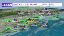
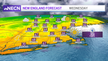
Southern areas will still manage 70-plus degrees, despite the scattered showers and downpours. A few thunderstorms will be possible too, but expect any rumbles to be below severe thresholds. We’ll all notice the cooler air by Wednesday, with highs in the 60s, and in the 50s far north.
Get Boston local news, weather forecasts, lifestyle and entertainment stories to your inbox. Sign up for NBC Boston’s newsletters.
Another round of showers is likely on Thursday before high pressure builds to end the week. This will mean a great stretch of fall weather through the weekend and into the start of next week, with cool mornings, highs in the 60s and mainly dry conditions.
