It’s another wild week of weather. While that overused sentence gets the message across, I think exhaustive might better sum up this pattern.
Just as soon as we get settled with a certain type of weather, the polar opposite is lurking around the corner. For all the wild weather we’ve seen in the past two months, we’re back to a barren landscape and facing another week of record-setting warmth.
Might be good for business, but it’s hard to wrap your head around the reason for all these extremes. Climate change is pulling the strings, but it takes an orchestra of coordination to keep this machine humming.
Get Boston local news, weather forecasts, lifestyle and entertainment stories to your inbox. Sign up for NBC Boston’s newsletters.
My feeble explanation is that the jet stream has been sending airmasses from all over North America at us. We are at the crossroads of many of these storm tracks, and as individual storms reach maturity overhead, they “bring the goods” in all respects. High winds, heavy precipitation, harsh cold, and record warmth.
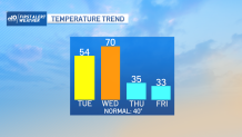
All of the above again this week. We’re in the warmup phase of that saga into midweek. Today it’s the rain sweeping in with a warm front. It won’t really kick into high gear until this afternoon and tonight, however. It’s then that we get a few downpours, see the wind kick up (with gusts over 30 mph), and nudge the temps into the 50s.

Plenty of leftover warmth will be around tomorrow, too. After the clouds break in the morning, we’ll skyrocket up to near 70 degrees – likely tying or breaking the record of 68 in Boston set way, way, way back in...2017… when Lorde came out with Melodrama and Kendrick Lamar came out with Damn.
Weather Stories


If that isn’t prophetic for the weather this week, I don’t know what is.
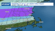
We’ll slide back to the cold on Thursday and await the next dump of snow by Friday. This one is a sure bet for wintry weather, but we’re wrestling with how much mixing with ice will occur. Right now it bisects the Commonwealth in half along the Pike.
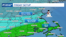
To the north, it seems like we have the best chance for all snow. To the south, the best chance for mix (and rain on the Cape). At stake is a solid 7-10 inches of snow with this round. It hits before dawn on Friday and rolls right into the evening. Most difficult travel will be early morning through noon.
Should firm up the lines by midweek. Stay with us for updates in the days ahead.