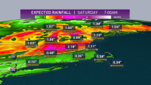
A stalled front from Texas to New England is generating pulses of heavy rain for over 1,700 miles from Dallas to Boston.
Over the southeastern United States, it’s warm and humid like summer time. Over the Rockies and much of Canada, it’s cold like early spring.
Along the boundary between the two air masses we have waves of energy producing torrential downpours in the central Plains today, expanding into New England this afternoon and overnight, continuing tomorrow.
The wettest weather so far today has been in southwestern New England, where it’s now getting brighter and drier. The rain is shifting to the north and east and becoming heavy at times, with perhaps an embedded thunderstorm.
Get Boston local news, weather forecasts, lifestyle and entertainment stories to your inbox. Sign up for NBC Boston’s newsletters.
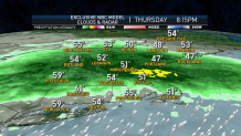
We are not expecting any damaging thunderstorm wind or hail, but there can be some gusty weather with some small hail in some of the heavier downpours. The area of rain is slowly expanding toward the north and east, exiting most of southern New England in the middle of the night tonight.
Temperatures for the most part are in the 50s with patchy dense fog between the rain showers. Northern Maine has the best weather with sunshine and temperatures near 70°.
Weather Stories

The tide is running very strong along the coast, thanks to the moon this week. We may have some minor coastal flooding with the midnight to 2 a.m. high tide.
Waves of low pressure rippling along the front will gradually shift toward the north tonight, and tomorrow move the heaviest rain into Vermont, New Hampshire, and Maine.
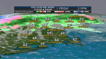
These multiple waves of low pressure are going to consolidate over eastern Maine tomorrow. As that occurs we may have a little bit of sunshine in southern New England with temperatures in the 60s, but the wind will increase dramatically tomorrow afternoon and evening, gusting past 40 mph for a few hours.
It’s going to be a colder wind in western New England, where rain may change to snow before ending. This includes the hills of western Massachusetts and Connecticut too.
It’ll all be happening while we are asleep tomorrow night. Mountains of Vermont and western Massachusetts may end up with a couple of inches of snow. For most of us though it is just a nice drink of (rain) water, with potential localized two or more inches of rain from now to Saturday morning.
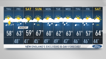
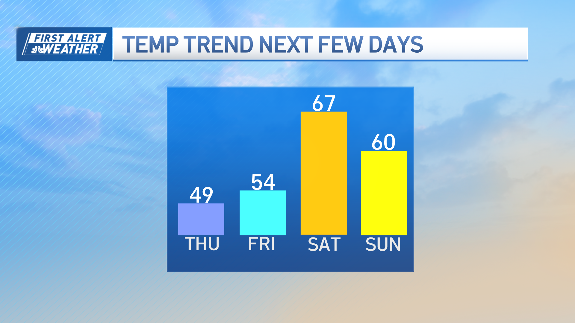
Saturday starts off cold and windy, but there’s a nice recovery. With a good amount of sunshine most of us should get up to near 60° with less wind for the afternoon. In Louisville, Kentucky, the sun will be shining with the temperatures near 70° for the Kentucky Derby.
Some more rapid-fire changes are in the forecast again starting Saturday night as another front whips through with a chance of a few showers at night and first thing Sunday.
It now looks like Sunday may be a pretty nice day with most of us getting sunshine and temperatures well into the 60s, perhaps low 70s south.
The biggest change to our forecast is that it now looks like we are going to be on the cold side of a new stationary front early next week. So we’ve had to lower the temperature forecast dramatically, plus add off and on rain starting Monday, and continuing most of the week. It’s a highly volatile and ever-changing First Alert 10-Day Forecast.