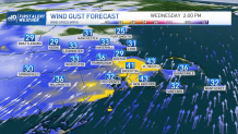
Don’t let the cold start fool you. Winds will quickly stir this morning and initiate a speedy warmup through the afternoon. Unfortunately, to move all the cold out – and to bring the warmth in – we have to get the wind cranking. And yes, we’re just as tired of it as you are.
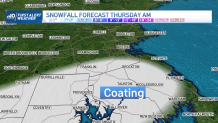
Gusts could top 40 mph in spots, mainly southeastern Massachusetts, the Cape and the Islands. The winds will back off later tonight as the cold front approaches…and then stalls. This will allow a batch of light rain to move in toward morning on Thursday, which quickly turns to light snow through the morning ride.
With mild overnight temps, the first flakes shouldn’t be much of an issue. However, as the temperatures continue to slide, some of the snow will stick. Some slick spots are possible, but the pacing of the snow will be light and in many cases spotty.
Get Boston local news, weather forecasts, lifestyle and entertainment stories to your inbox. Sign up for NBC Boston’s newsletters.
This forecast has large bust potential since we’re trying to time the arrival of the cold with the burst of precipitation. If the timing is off, this could just be some rain ending as snow…with little or no accumulation. As it stands now, the accumulations should be light: generally a coating to 1” – favoring points south of Boston and Worcester.
Cold continues to pour in Thursday night and Friday. Deep arctic air will be entrenched to lead into the weekend, and its presence could thwart the next storm trying to moving into southern New England.
A coastal storm will creep along the Eastern Seaboard on Saturday. Seems most of the guidance wants to push it farther away from us. If trends hold, it could push it away entirely. Time will tell. We’ll keep you apprised.