
We’re dealing with an abnormally warm evening across much of southern New England Thursday as mild air continues to flow into the area via a gusty southerly wind.
It’ll remain mild and breezy overnight, even after a cold front slides through the region early in the morning, which will basically switch the wind direction from southwest to northwest. Lows will drop into the upper 40s to low 50s south, 30s and 40s north.
Temperatures will remain above average again Friday -- in fact, it’ll remain downright mild across southern areas! We’ll see a good amount of sunshine as well with a gusty northwest wind, making it feel a bit cooler. Highs mid 40s to low 50s south, upper 30s to mid 40s north.
Get Boston local news, weather forecasts, lifestyle and entertainment stories to your inbox. Sign up for NBC Boston’s newsletters.
Cold air will drain into the region Friday night from the north and will set the stage as another system arrives Saturday morning with more precipitation.
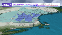
Even though we’re expecting this system to take a track just south of New England, which usually means snow, the lack of cold air in place means we’re likely going to see snow to rain across Boston.
Currently, it looks like it’ll be mostly wet along the coast, with some snow at the onset and perhaps again later Saturday night into Sunday morning as precipitation winds down.
Interior locations such as northern Worcester County into New Hampshire will see the best chance for frozen precipitation, and north of that will likely be all snow, with several inches likely across those areas. For this reason, our weather team as issued a First Alert for Saturday!
Precipitation will wind down Sunday morning across southern areas, with some lingering snow showers across northern New England through the afternoon. Where we do see all snow, several inches will likely fall, creating some travel issues.
We’re still tweaking snowfall totals being more than 36 hours or so away from the event, so please check back with us as we continue to monitor it closely…
