You may be wishing we stayed in the clouds and showers by the end of the week.
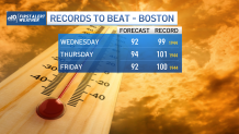
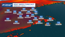
It’s coming back around again. A summer heat wave is still on the menu for midweek - and the humidity isn’t going anywhere. That translates to heat indices that approach 100 on Wednesday and Thursday.
Boston Mayor Kim Janey on Tuesday announced a heat emergency in the city Wednesday through Friday, opening cooling centers and tot sprays. Details here.
"I am urging everyone to drink lots of water and find ways to stay cool. Anyone who needs a place to beat the heat can come inside and rest in the air conditioning at one of our cooling centers," she said in a statement.
Get Boston local news, weather forecasts, lifestyle and entertainment stories to your inbox. Sign up for NBC Boston’s newsletters.
We seem light years away from that Tuesday morning. Clouds, fog, leftover sprinkles/showers – it’s like the 4th of July all over. We’ll slowly weasel our way out of the overcast and wet weather Tuesday afternoon.
I’m expecting a keen rebound to the low 80s in many spots away from the coast. Again tomorrow we may wake to some patchy fog (nights are getting a bit longer, allowing fog to form), but with a shift in the wind direction, we’re off to the races.
Air will stay thick with humidity through the end of the week. Relief will have to wait until the weekend.
A slow-moving front will approach on Friday, heightening the risk for storms into Saturday. We’ll have to watch for severe weather at that time as well. In addition, the smoke from the wildfires may waft into the region as our upper level winds steer plumes in our direction.
The tropics are heating up too. A newly-named storm (Fred) should be marching through the Northern Caribbean today. The official forecast aims this storm towards Cuba and southern Florida through the late week/weekend.
All eyes will be on Fred as it tries to maintain tropical storm strength while bumping into Puerto Rico and Hispaniola along the way.