
An overview of the storm across the U.S. and in New England
A strengthening storm will emerge from the Rocky Mountains later today and undergo rapid intensification as it crosses the central US tomorrow. Blizzard warnings and winter storm warnings/advisories have been issued from the areas of the mountainous west coast to parts of the eastern seaboard as this system will produce several impacts including damaging winds, heavy snow and flooding rain. While our weather is quiet at the moment, rain and snow will arrive tomorrow evening with the height of the storm in New England on Friday. Let’s break down the details.
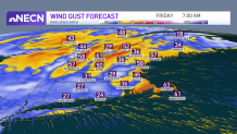
Strong winds threaten outages
I think strong wind gusts regionwide will be the thing folks remember most from this storm. The first burst of wind from the southeast will likely be strongest, with gusts over 60 mph possible at the North & South Shore, Southeast Mass, Cape Cod and also on the northwest slopes of the Green Mountains, resulting in scattered power outages regionwide. A secondary burst of wind later in the afternoon will feature numerous gusts 40-50 mph, still sufficient for some pockets of damage and impacting different areas than the earlier southeast wind. While the wind won’t be as strong on Saturday, gusts in the 30-40 mph range will certainly hinder cleanup and restoration efforts.
Get Boston local news, weather forecasts, lifestyle and entertainment stories to your inbox. Sign up for NBC Boston’s newsletters.
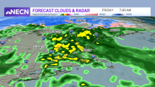
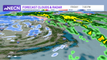
Heavy rain expected Friday
Tomorrow will start off cloudy but dry until scattered showers arrive late in the day. Showers turn to a steadier light rain during the evening, with heavier elements arriving late evening and continuing overnight. Downpours will be heaviest from pre-dawn into mid-morning Friday before a brief lull in the action late morning to midday. After that, a second surge of rain and embedded downpours will move in. Rainfall totals will generally run around 2” with localized flooding, ponding of water and hydroplaning concerns.
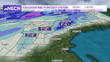
What areas of New England will see snow?
While areas of rain will expand Thursday evening, it will be cold enough for precipitation to start as snow in northern and western New England. We may even see a quick burst west of I-91 in Massachusetts and perhaps briefly in Northern Worcester County to Southwest New Hampshire, before fairly quickly changing to rain and continuing through Thursday night, while the Green Mountains, White Mountains, Northern Lakes Region and Western Maine see 1”-4” of snow, with as much as half a foot possible from the Presidentials to the Mountains of Maine, where snow will fall into Friday morning before changing to rain. It’s also important to mention that Friday evening as the surge of cold air moves in, some scattered snow showers and squalls may drop a quick coating in a few communities, all the way to southern New England.
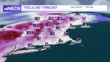
Flash freeze potential as temps drop Friday night
Highs in the 50s Friday afternoon will be but a distant memory by late in the day as cold air blasts into the region. Behind the front, temperatures will drop rapidly Friday evening, causing leftover moisture on the roads to freeze quickly. Flash freeze events are tricky to nail down – but as of right now, the 6 p.m - 8 p.m. timeframe is our main concern.
More on the storm


Expect single-digit wind chills
Wind chill values will quickly drop into the single digits on Friday evening as the blast of cold air moves into the region. North and west of Boston, SUB-ZERO feels like temperatures overnight Friday will linger into the early morning hours on Saturday. Our holiday weekend stays chilly, with highs only in the 20s and wind chill values in the teens both Christmas Eve and Christmas Day.
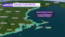
Coastal flooding concerns
The wind over the ocean will create 15-25 foot waves offshore with near-shore waves of 7-12 feet and a high tide already running at a high-level thanks to the upcoming New Moon. What does that mean for those along the immediate coast? Widespread minor coastal flooding is likely, with pockets of moderate coastal flooding not out of the question in vulnerable southeast and south facing coasts with a late morning high tide for most. When the high tide repeats prior to midnight Friday night, the southwest wind will mitigate the coastal flood threat for many, though south-facing coasts may still see some minor flooding. Significant beach erosion is likely at south and east facing shorelines especially.
Be prepared for your day and week ahead. Sign up for our weather newsletter.
