
An impressive backdoor cold front created quite the temperature difference across southern New England on Thursday and brought with it a risk for severe storms.
There are severe thunderstorm warnings for Litchfield County, Connecticut and Berkshire County, Massachusetts.
High temperatures will rise into the mid 70s to 80 degrees across Connecticut, while at the coast it will only rise into the mid 40s to 50 degrees. This setup will trigger showers and thunderstorms -- some severe -- across eastern New York, western Massachusetts and Connecticut, while eastern Massachusetts, Maine and New Hampshire remain cloudy, cool and dry. Stronger storms may feature the potential for damaging wind gusts.
Overnight, any showers and thunderstorms will wane as they trek eastward, entering the cool and stable air mass in place. Lows will drop down into the low 40s south and mid to upper 30s north.
Get Boston local news, weather forecasts, lifestyle and entertainment stories to your inbox. Sign up for NBC Boston’s newsletters.
Friday features drier air and plenty of sunshine across the region, with highs rising into the mid 60s to 70 degrees south and mid 50s to 60 degrees across the North Country. The sun should be shining as the Boston Red Sox face off against the Minnesota Twins at 2:10 p.m. in their home opener, and we're expecting a pleasant evening Friday night for those observing the first night of Passover.
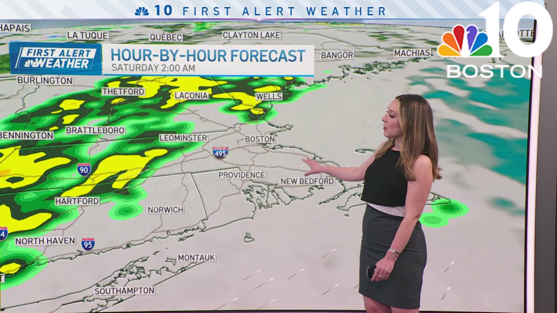
Clouds move back into New England on Saturday as a disturbance approaches from the west. Showers will develop early in the day and diminish briefly through the afternoon before ramping up again after dinner ahead of an approaching cold front. Winds will ramp up during the day as well, gusting 20 to 30 mph. Highs will reach into the mid to upper 60s south and low to mid 50s across the north.
Weather
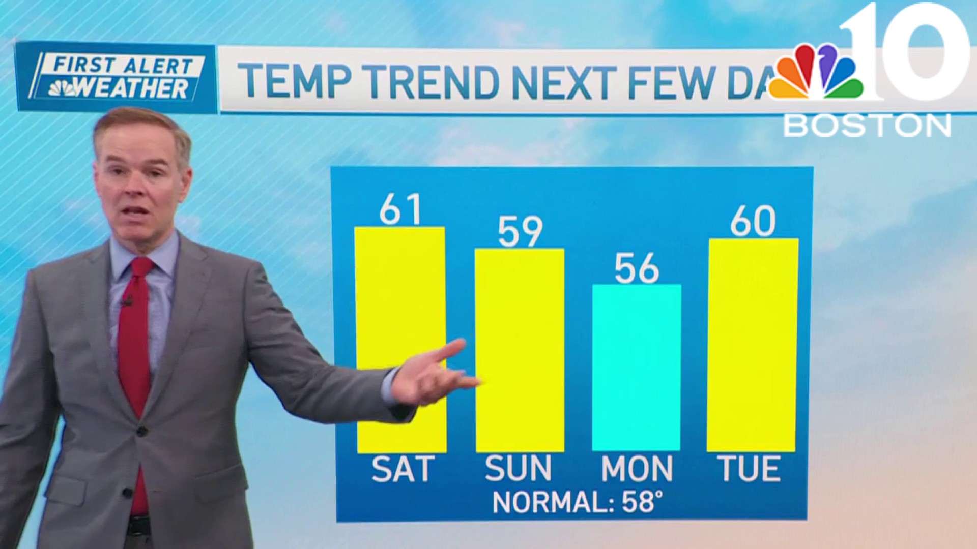
A northwest flow will develop behind the departing cold front on Easter Sunday, bringing temperatures back down close to normal for mid-April. Highs will struggle to rise above the mid 50s thanks to the colder air mass in place. Those suffering from pollen allergies can expect continued discomfort through the weekend. We're expecting an overall dry day with daytime clouds and a spot shower or two.
Looking ahead to next week, Marathon Monday features an area of high pressure building into New England, supporting clear skies for part of the day. As the stable air mass shifts offshore, winds will flip out of the southwest and clouds will stream back into the region. This will likely result in a crosswind for athletes competing from Hopkinton to Boston during the morning. Highs will remain seasonable in the upper 50s to low 60s.
A low pressure system may bring significant precipitation to the region on Tuesday, with even a couple inches of spring snow across the higher terrain of the Berkshires and interior New England.
Behind the departing coastal storm, we’ll dry out with pleasant weather through the rest of school vacation week on the exclusive First Alert Weather 10-Day Forecast on NBC10 Boston and NECN.
