
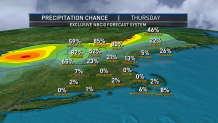
Although the wind has come down in magnitude for New England Thursday, gusts still reach 40 to 45 mph, particularly in higher terrain. While this may result in a few downed limbs and new power outages, the bigger impact is the blustery wind chill, making high temperatures in the lower 40s and 30s north feel like the 20s most of the day and likely causing occasional summit chairlift holds at some ski mountains.
This wintry feeling is accompanied by scattered snow showers in the mountains, and occasional flurries for the rest of New England, as moisture blowing off the Great Lakes migrates east with the clouds able to survive under a cold sky. As clouds melt away Thursday evening, the wind will gradually quiet, but will still be steady enough for a wind chill in the 20s through the evening, including for tailgaters at Gillette Stadium. By the time the Patriots and Bills kick off, the wind should be down to about 10 mph, with a limited impact on the game, a continued wind chill in the 20s and an actual temperature of 34 degrees.
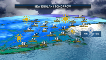
Overnight lows in the 20s give way to a cool but fair day with a much lighter wind Friday, making high temperatures in the 40s feel decidedly better than Thursday. In a busy weather pattern with a fast-moving jet stream aloft – the fast river of air, high in the sky, that steers storms and disturbances – the next storm comes calling on Saturday.
Get Boston local news, weather forecasts, lifestyle and entertainment stories to your inbox. Sign up for NBC Boston’s newsletters.
Much like its midweek predecessor, this storm will strengthen over southern Canada, grabbing moisture from as far away as the Gulf of Mexico, and the counterclockwise wind flow around the storm center will deliver a strong southerly wind with mild air to New England on Saturday. That will ensure the bulk of this storm’s precipitation falls as rain, even in the mountains of Ski Country.
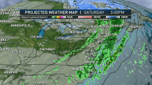
Overall, Saturday’s wind gusts are unlikely to be as strong as Wednesday evening’s gusts to 50 and 60 mph, with most gusts on the order of 35 to 45 mph Saturday afternoon and evening. The passage of a Saturday evening cold front will deliver another shot of drier and cooler air for Sunday, when a fair sky with high temperatures in the 40s will be accompanied by a fresh northwest breeze, but not a powerful wind.
Yet another mild storm system strengthens over southern Canada early next week, returning showers and a relatively warm breeze to New England Monday night through Tuesday – but what follows is a change to the pattern. For nearly two weeks our First Alert team has been advertising a colder weather pattern starting up in early December – we’ve pegged that transition as next Thursday in the 10-day forecast.
Though that certainly brings no guarantee following storms will be snow instead of rain for all of New England, it does mark a noticeable shift to wintry air and, therefore, certainly raises the chance of more snow involved with any storms that develop.
