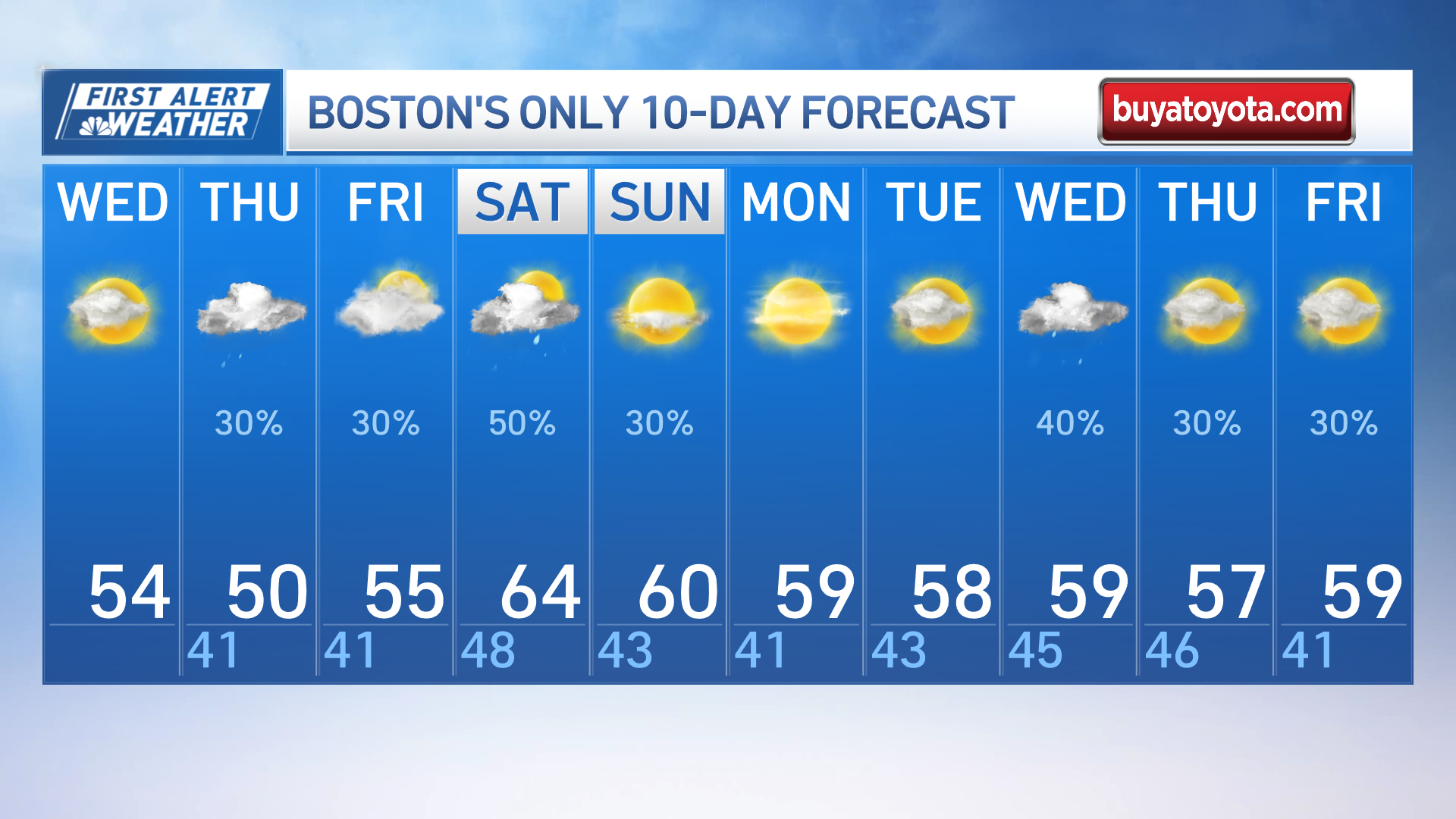
Wednesday night: Mostly cloudy. Scattered rain. Lows in the low 40s. Thursday: Scattered rain south. Highs in the mid 50s. Thursday night: Patchy drizzle. Mostly cloudy by daybreak. Low around 40. Friday: Partly sunny. Highs around 60. Saturday: A few morning showers. Partly sunny, highs near 65.
Wednesday is a transition day, as we see lowering temperatures and increasing clouds. Highs only top off in the 40s to low 50s at the coast, while inland we still manage to reach the 60s before clouds take over.
Scattered showers slowly move into Connecticut and western Massachusetts late Wednesday afternoon. Keep the umbrella handy through Thursday, as these showers spread slowly eastward overnight. However, minimal rain accumulation is expected across the area, with around 0.5 inches of rain through Sunday in Connecticut and around 0.1 of an inch in eastern Massachusetts.


The scattered showers continue to hold across southern and western New England throughout Thursday as a warm front stalls nearby but doesn’t move through completely. So temps will be much cooler for all, with the clouds and rain around, along with an onshore flow, in the 40s and 50s for all of the northeast. The exception is in Maine, where you see more sun and temps around 60 inland.
Get Boston local news, weather forecasts, lifestyle and entertainment stories to your inbox. Sign up for NBC Boston’s newsletters.
We have a break from rain on Friday as temps stay in the 50s for most. Friday night, a cold front approaches and moves through Saturday afternoon. This timeframe is our best chance for any widespread rainfall. The showers seem to exit the coast by noon Saturday for most. The front is close enough offshore that a couple afternoon showers develop in southeastern Massachusetts, but not a huge deal.
Highs jump to the mid 60s once we clear the sky Saturday afternoon. Dry weather settles in again with highs around 60 at the coast Sunday through the start to next week, and 60s inland.