


Wednesday night: Slight chance of showers overnight, mostly cloudy, northwest wind. Thursday: Showers in the morning, mostly sunny in the afternoon. Northwest wind 7-9 mph, chance of showers 30%.
Keep the jackets ready, because we'll see temperatures drop into the 40s Wednesday night.
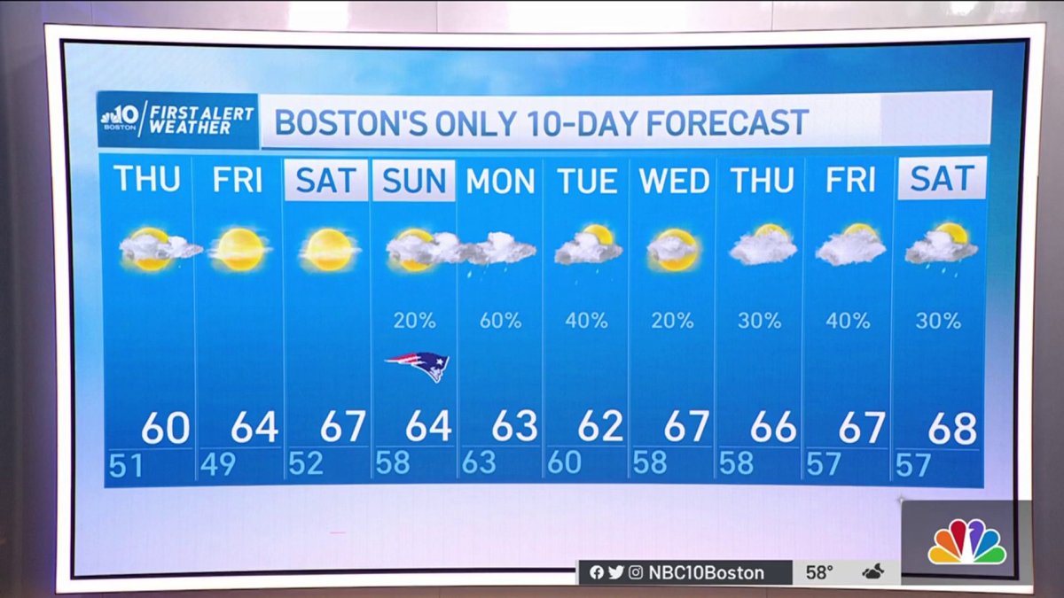
We got the chance to enjoy a decent day with temperatures just below average and some sunshine in the south. Now, we'll be watching a change in the weather pattern; our temperatures will drop even more Wednesday into Thursday, and our rain chances will increase.
We have an upper level low that will move overhead Wednesday night and keep our skies partly cloudy for the overnight hours with the chance for isolated to scattered showers. We have a pool of cool air and wind from the west-northwest.
We can expect the potential for isolated or widely scattered showers that will mainly focus in the eastern side of New England. Daytime heating will increase the vertical lapse rate that may wake up some isolated thunderstorms. We might even see some small hail stones produced by some of the stronger cells (mainly in the north), while the interaction of warmer air from the ocean could develop some additional showers in the east.
Get Boston local news, weather forecasts, lifestyle and entertainment stories to your inbox. Sign up for NBC Boston’s newsletters.
The coolest and more unstable day of the week for now through Saturday will be Thursday. Our highs will stay in the upper 50s to low 60s, and we'll be watching isolated rain chances with embedded stronger cells along with thunder for some.
Friday should be one of the best days for outdoor activities, as we'll enjoy mostly clear skies and our highs will remain closer to the mid 60s.
Local
In-depth news coverage of the Greater Boston Area.


Practically, the first week of October should range in the mid to upper 60s and lows from the mid to low 50s. Saturday looks to be the pick of the weekend, with highs in the mid to upper 60s, a few spots reaching low 70s and a possible high in control, allowing for a sunny day with dry northwest flow.
Sunday will begin to unwrap unsettled weather again, with the chance for some additional showers, mainly coming off the north and western areas of New England. As our focus remains on Sunday's game weather, we'll make sure to track it closely.
Meanwhile in the Atlantic, we're tracking Hurricane Sam, which will stay far away from New England, but close enough to increase our wave height, which will range from 6-10' this weekend and allow for dangerous rip currents.
Stay tuned on NBC10 Boston and NECN for all the updates.

