


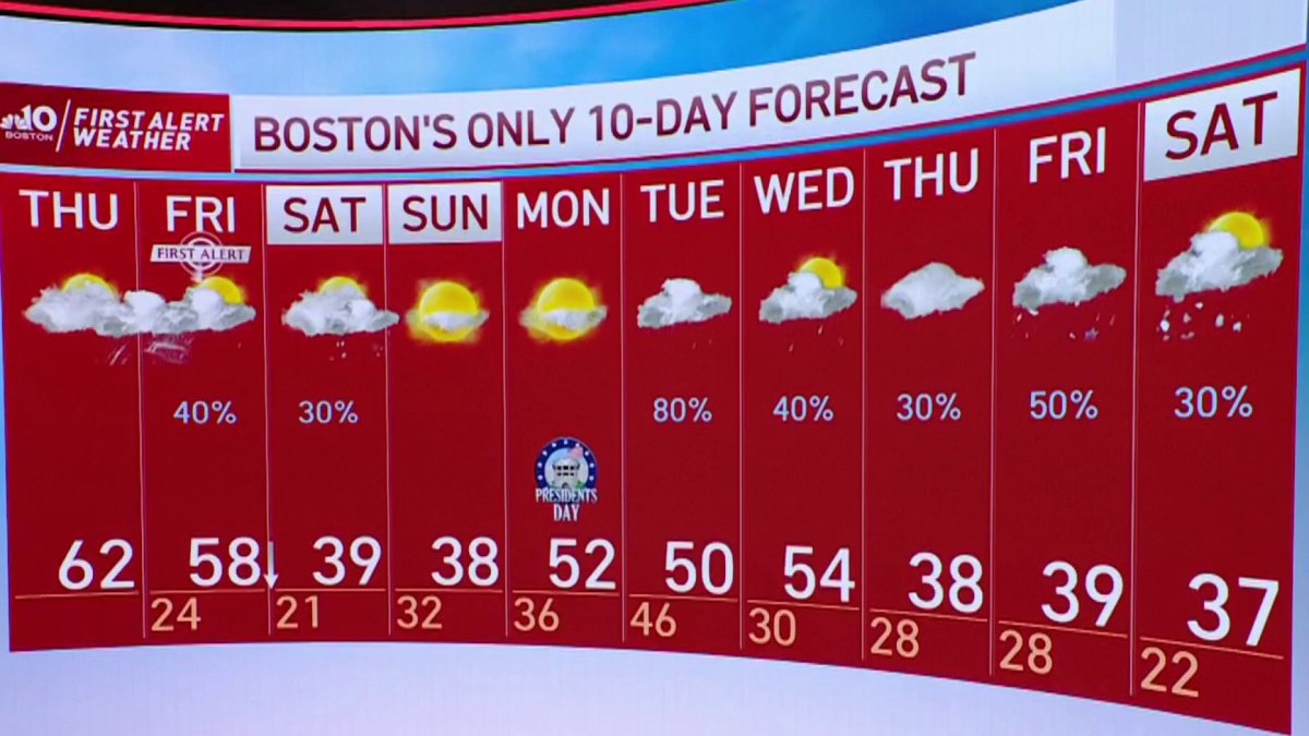
From the NBC10 Boston First Alert Weather Center… Today (Thursday): Windy, mild, sprinkle. Highs near 60. Overnight Thursday Night: Rain, damaging southwest wind gusts. Temperatures in the 50s. Friday: AM rain/wind to midday/PM sun, early highs near 60 drop to 30 by day’s end. Cape Cod Radio Forecast: Today (Thursday): Windy, mild, a sprinkle from time to time. Highs in the 50s. Southwest gusts to 50 mph. Overnight Thursday Night: Rain, scattered wind damage and power outages from southwest gusts over 60 mph. Temperatures in the 50s. Friday: AM rain/wind to PM sun, early highs near 60 drop to the 30s by day’s end.
The mild wind expected in New England wasted no time cranking up Thursday and a First Alert continues for NBC10 Boston and NECN for strengthening gusts capable of scattered power outages overnight Thursday.
Records were set even before midday Thursday in some of New England, with Worcester, Massachusetts, and Manchester, New Hampshire, surpassing their previous records of 56 degrees set in 1981 and 2011, respectively.
Other record high temperatures likely will fall, including Boston’s record of 61 degrees from 1981, with Burlington, Vermont (53), Portland, Maine (58), and Concord, New Hampshire (58), all looking especially vulnerable.
Get Boston local news, weather forecasts, lifestyle and entertainment stories to your inbox. Sign up for NBC Boston’s newsletters.
The warmth won’t fade much overnight Thursday, even as scattered evening showers become a steadier rain from northwest to southeast, from late day to late evening, respectively – winds from the southwest will crank all night long and keep many communities in the 50s!
Of course, the roaring overnight wind from the southwest not only will keep some New Englanders awake as it gusts beyond 50 mph – and over 60 mph for some – but also will send a collection of tree limbs crashing down for scattered overnight power outages that will last into Friday morning.
As a sharp, well-defined cold front approaches from the west, rain will focus to downpours between midnight and 8 a.m. Friday, combining with melting snow to form big puddles and some urban street flooding to slow the morning commute.
By middle to late morning Friday, the cold front will pass through New England, shifting the wind direction to blow from the northwest and starting a quick flow of colder air from Canada that will take early morning temperatures around 60 degrees and send them crashing into the 20s by evening!
Although this comes with a clearing sky after any mountain flurries end, a new disturbance approaches from the west Saturday with enough energy aloft to prompt scattered snow showers, though accumulations should be little if any except for northern New England, where a coating to two inches of snow is possible.
By Sunday, dry and cool air dominates for a bright sky ahead of a renewed warming trend in the first half of next week, with high temperatures returning to the 50s. There will be a lot of cold air bundled across the border in Canada, however, so by week’s end that cold will probably press southward into New England, and with a feed of disturbances aloft in an active jet stream pattern, a messy winter combination of precipitation is possible Thursday or Friday Our First Alert Team will be able to fine tune that as we get closer.

